You are here: Home > Network List > WI - West Indies IPGP Network Stations List
> Station SAM Savane Anatole - Martinique > Earthquake Result Viewer
SAM Savane Anatole - Martinique - Earthquake Result Viewer
| Earthquake location: |
Southern Alaska |
| Earthquake latitude/longitude: |
59.7/-153.5 |
| Earthquake time(UTC): |
2016/01/24 (024) 10:30:30 GMT |
| Earthquake Depth: |
128 km |
| Earthquake Magnitude: |
7.1 MWW, 6.4 ML |
| Earthquake Catalog/Contributor: |
NEIC PDE/NEIC COMCAT |
|
| Network: |
WI West Indies IPGP Network |
| Station: |
SAM Savane Anatole - Martinique |
| Lat/Lon: |
14.84 N/61.17 W |
| Elevation: |
510 m |
|
| Distance: |
78.5 deg |
| Az: |
80.458 deg |
| Baz: |
328.821 deg |
| Ray Param: |
0.04931302 |
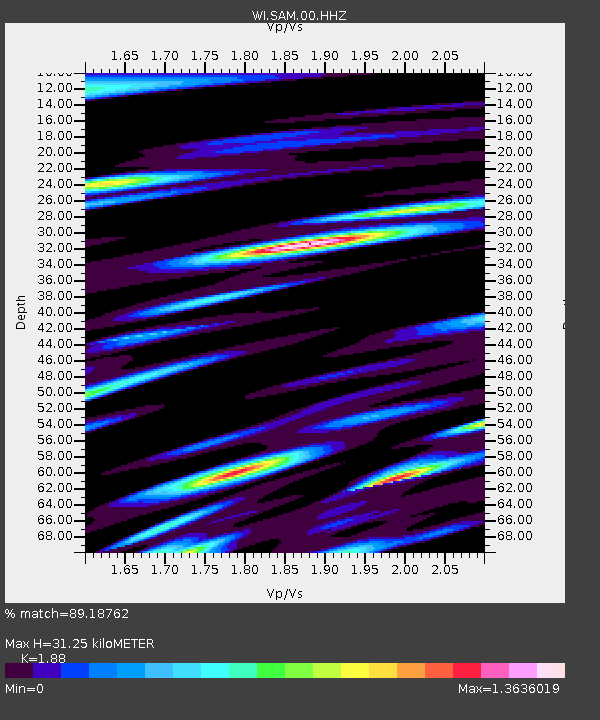
| Estimated Moho Depth: |
31.25 km |
| Estimated Crust Vp/Vs: |
1.88 |
| Assumed Crust Vp: |
5.88 km/s |
| Estimated Crust Vs: |
3.128 km/s |
| Estimated Crust Poisson's Ratio: |
0.30 |
|
| Radial Match: |
89.18762 % |
| Radial Bump: |
400 |
| Transverse Match: |
83.48342 % |
| Transverse Bump: |
400 |
| SOD ConfigId: |
7422571 |
| Insert Time: |
2019-04-21 19:47:11.442 +0000 |
| GWidth: |
2.5 |
| Max Bumps: |
400 |
| Tol: |
0.001 |
|

Signal To Noise
| Channel | StoN | STA | LTA |
| WI:SAM:00:HHZ:20160124T10:41:45.439995Z | 3.1122284 | 1.9697623E-6 | 6.329106E-7 |
| WI:SAM:00:HHN:20160124T10:41:45.439995Z | 1.6807072 | 2.3308262E-6 | 1.3868126E-6 |
| WI:SAM:00:HHE:20160124T10:41:45.439995Z | 1.1173273 | 1.8003251E-6 | 1.6112782E-6 |
| Arrivals |
| Ps | 4.8 SECOND |
| PpPs | 15 SECOND |
| PsPs/PpSs | 20 SECOND |


