You are here: Home > Network List > XL12 - Hangay Dome, Mongolia Stations List
> Station AT09 AT09 > Earthquake Result Viewer
AT09 AT09 - Earthquake Result Viewer
| Earthquake location: |
Southern Alaska |
| Earthquake latitude/longitude: |
59.7/-153.5 |
| Earthquake time(UTC): |
2016/01/24 (024) 10:30:30 GMT |
| Earthquake Depth: |
128 km |
| Earthquake Magnitude: |
7.1 MWW, 6.4 ML |
| Earthquake Catalog/Contributor: |
NEIC PDE/NEIC COMCAT |
|
| Network: |
XL Hangay Dome, Mongolia |
| Station: |
AT09 AT09 |
| Lat/Lon: |
44.93 N/95.56 E |
| Elevation: |
1861 m |
|
| Distance: |
61.5 deg |
| Az: |
311.006 deg |
| Baz: |
32.642 deg |
| Ray Param: |
0.060474727 |
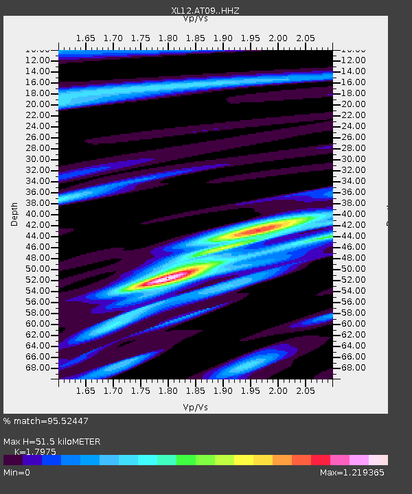
| Estimated Moho Depth: |
51.5 km |
| Estimated Crust Vp/Vs: |
1.80 |
| Assumed Crust Vp: |
6.353 km/s |
| Estimated Crust Vs: |
3.534 km/s |
| Estimated Crust Poisson's Ratio: |
0.28 |
|
| Radial Match: |
95.52447 % |
| Radial Bump: |
400 |
| Transverse Match: |
88.11272 % |
| Transverse Bump: |
400 |
| SOD ConfigId: |
7422571 |
| Insert Time: |
2019-04-21 19:47:26.342 +0000 |
| GWidth: |
2.5 |
| Max Bumps: |
400 |
| Tol: |
0.001 |
|

Signal To Noise
| Channel | StoN | STA | LTA |
| XL:AT09: :HHZ:20160124T10:40:02.749016Z | 52.631695 | 5.9523068E-6 | 1.1309358E-7 |
| XL:AT09: :HHN:20160124T10:40:02.749016Z | 24.759447 | 2.498198E-6 | 1.00898774E-7 |
| XL:AT09: :HHE:20160124T10:40:02.749016Z | 20.90843 | 1.3672715E-6 | 6.539331E-8 |
| Arrivals |
| Ps | 6.8 SECOND |
| PpPs | 22 SECOND |
| PsPs/PpSs | 28 SECOND |


