You are here: Home > Network List > XL12 - Hangay Dome, Mongolia Stations List
> Station AT13 AT13 > Earthquake Result Viewer
AT13 AT13 - Earthquake Result Viewer
| Earthquake location: |
Southern Alaska |
| Earthquake latitude/longitude: |
59.7/-153.5 |
| Earthquake time(UTC): |
2016/01/24 (024) 10:30:30 GMT |
| Earthquake Depth: |
128 km |
| Earthquake Magnitude: |
7.1 MWW, 6.4 ML |
| Earthquake Catalog/Contributor: |
NEIC PDE/NEIC COMCAT |
|
| Network: |
XL Hangay Dome, Mongolia |
| Station: |
AT13 AT13 |
| Lat/Lon: |
44.99 N/96.27 E |
| Elevation: |
1091 m |
|
| Distance: |
61.2 deg |
| Az: |
310.556 deg |
| Baz: |
32.929 deg |
| Ray Param: |
0.06067986 |
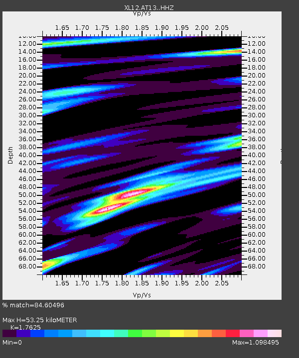
| Estimated Moho Depth: |
53.25 km |
| Estimated Crust Vp/Vs: |
1.76 |
| Assumed Crust Vp: |
6.353 km/s |
| Estimated Crust Vs: |
3.605 km/s |
| Estimated Crust Poisson's Ratio: |
0.26 |
|
| Radial Match: |
84.60496 % |
| Radial Bump: |
400 |
| Transverse Match: |
71.69232 % |
| Transverse Bump: |
400 |
| SOD ConfigId: |
7422571 |
| Insert Time: |
2019-04-21 19:47:27.622 +0000 |
| GWidth: |
2.5 |
| Max Bumps: |
400 |
| Tol: |
0.001 |
|

Signal To Noise
| Channel | StoN | STA | LTA |
| XL:AT13: :HHZ:20160124T10:40:00.59002Z | 50.158836 | 5.8900905E-6 | 1.17428776E-7 |
| XL:AT13: :HHN:20160124T10:40:00.59002Z | 17.218773 | 2.547856E-6 | 1.4796966E-7 |
| XL:AT13: :HHE:20160124T10:40:00.59002Z | 6.653733 | 1.6851808E-6 | 2.5326847E-7 |
| Arrivals |
| Ps | 6.7 SECOND |
| PpPs | 22 SECOND |
| PsPs/PpSs | 29 SECOND |


