You are here: Home > Network List > IU - Global Seismograph Network (GSN - IRIS/USGS) Stations List
> Station FURI Mt. Furi, Ethiopia > Earthquake Result Viewer
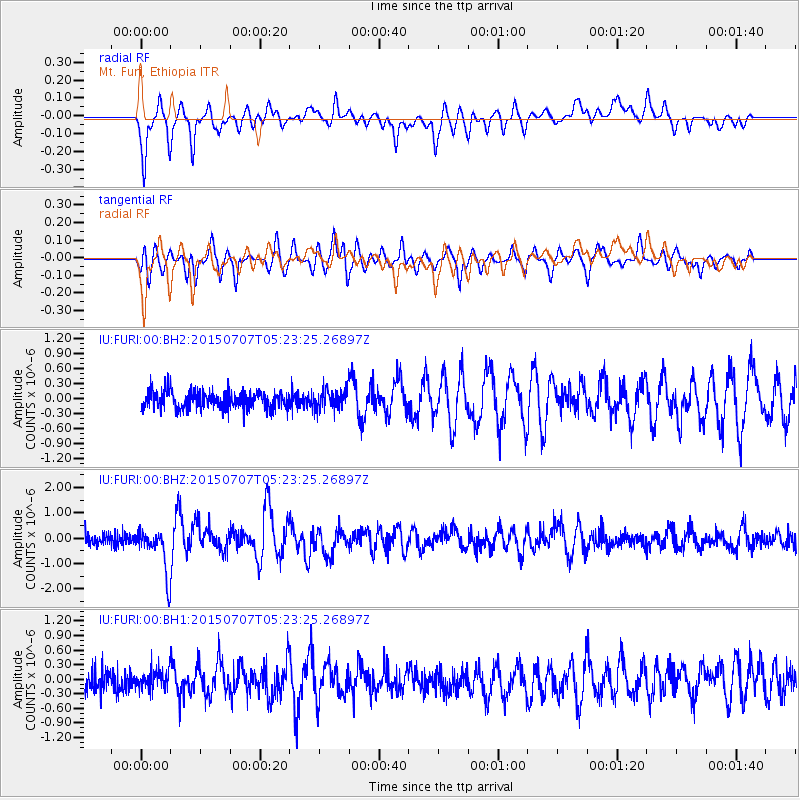
FURI Mt. Furi, Ethiopia - Earthquake Result Viewer
*The percent match for this event was below the threshold and hence no stack was calculated.
| Earthquake location: |
Kuril Islands |
| Earthquake latitude/longitude: |
44.0/147.9 |
| Earthquake time(UTC): |
2015/07/07 (188) 05:10:27 GMT |
| Earthquake Depth: |
38 km |
| Earthquake Magnitude: |
6.3 MO |
| Earthquake Catalog/Contributor: |
NEIC PDE/NEIC ALERT |
|
| Network: |
IU Global Seismograph Network (GSN - IRIS/USGS) |
| Station: |
FURI Mt. Furi, Ethiopia |
| Lat/Lon: |
8.90 N/38.68 E |
| Elevation: |
2570 m |
|
| Distance: |
97.4 deg |
| Az: |
289.831 deg |
| Baz: |
43.408 deg |
| Ray Param: |
$rayparam |
*The percent match for this event was below the threshold and hence was not used in the summary stack. |
|
| Radial Match: |
84.8493 % |
| Radial Bump: |
388 |
| Transverse Match: |
78.76807 % |
| Transverse Bump: |
392 |
| SOD ConfigId: |
976571 |
| Insert Time: |
2015-07-21 05:31:55.034 +0000 |
| GWidth: |
2.5 |
| Max Bumps: |
400 |
| Tol: |
0.001 |
|
Signal To Noise
| Channel | StoN | STA | LTA |
| IU:FURI:00:BHZ:20150707T05:23:25.26897Z | 3.8203552 | 8.754448E-7 | 2.2915273E-7 |
| IU:FURI:00:BH1:20150707T05:23:25.26897Z | 0.97191495 | 2.0020423E-7 | 2.0598945E-7 |
| IU:FURI:00:BH2:20150707T05:23:25.26897Z | 1.1425705 | 2.0239668E-7 | 1.7714153E-7 |
| Arrivals |
| Ps | |
| PpPs | |
| PsPs/PpSs | |


