You are here: Home > Network List > XL12 - Hangay Dome, Mongolia Stations List
> Station HV27 HV27 > Earthquake Result Viewer
HV27 HV27 - Earthquake Result Viewer
| Earthquake location: |
Southern Alaska |
| Earthquake latitude/longitude: |
59.7/-153.5 |
| Earthquake time(UTC): |
2016/01/24 (024) 10:30:30 GMT |
| Earthquake Depth: |
128 km |
| Earthquake Magnitude: |
7.1 MWW, 6.4 ML |
| Earthquake Catalog/Contributor: |
NEIC PDE/NEIC COMCAT |
|
| Network: |
XL Hangay Dome, Mongolia |
| Station: |
HV27 HV27 |
| Lat/Lon: |
50.54 N/101.51 E |
| Elevation: |
1140 m |
|
| Distance: |
54.6 deg |
| Az: |
310.883 deg |
| Baz: |
36.977 deg |
| Ray Param: |
0.064931415 |
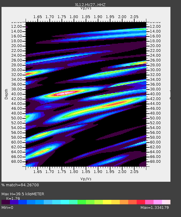
| Estimated Moho Depth: |
39.5 km |
| Estimated Crust Vp/Vs: |
1.76 |
| Assumed Crust Vp: |
6.419 km/s |
| Estimated Crust Vs: |
3.647 km/s |
| Estimated Crust Poisson's Ratio: |
0.26 |
|
| Radial Match: |
94.26708 % |
| Radial Bump: |
400 |
| Transverse Match: |
88.391136 % |
| Transverse Bump: |
400 |
| SOD ConfigId: |
7422571 |
| Insert Time: |
2019-04-21 19:47:45.341 +0000 |
| GWidth: |
2.5 |
| Max Bumps: |
400 |
| Tol: |
0.001 |
|

Signal To Noise
| Channel | StoN | STA | LTA |
| XL:HV27: :HHZ:20160124T10:39:14.890007Z | 72.79288 | 8.781429E-6 | 1.2063582E-7 |
| XL:HV27: :HHN:20160124T10:39:14.890007Z | 27.186026 | 3.745098E-6 | 1.377582E-7 |
| XL:HV27: :HHE:20160124T10:39:14.890007Z | 22.818747 | 3.927819E-6 | 1.7213122E-7 |
| Arrivals |
| Ps | 4.9 SECOND |
| PpPs | 16 SECOND |
| PsPs/PpSs | 21 SECOND |


