You are here: Home > Network List > YN10 - San Jacinto Fault Zone Stations List
> Station JFS3 JFS3 > Earthquake Result Viewer
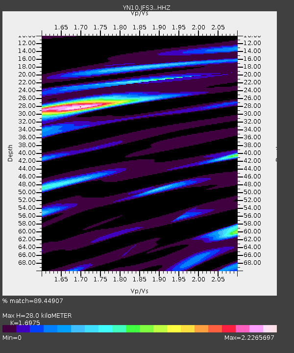
JFS3 JFS3 - Earthquake Result Viewer
| Earthquake location: |
Southern Alaska |
| Earthquake latitude/longitude: |
59.7/-153.5 |
| Earthquake time(UTC): |
2016/01/24 (024) 10:30:30 GMT |
| Earthquake Depth: |
128 km |
| Earthquake Magnitude: |
7.1 MWW, 6.4 ML |
| Earthquake Catalog/Contributor: |
NEIC PDE/NEIC COMCAT |
|
| Network: |
YN San Jacinto Fault Zone |
| Station: |
JFS3 JFS3 |
| Lat/Lon: |
33.42 N/116.40 W |
| Elevation: |
645 m |
|
| Distance: |
35.8 deg |
| Az: |
120.494 deg |
| Baz: |
328.461 deg |
| Ray Param: |
0.07660032 |
| Estimated Moho Depth: |
28.0 km |
| Estimated Crust Vp/Vs: |
1.70 |
| Assumed Crust Vp: |
6.264 km/s |
| Estimated Crust Vs: |
3.69 km/s |
| Estimated Crust Poisson's Ratio: |
0.23 |
|
| Radial Match: |
89.44907 % |
| Radial Bump: |
400 |
| Transverse Match: |
78.437126 % |
| Transverse Bump: |
400 |
| SOD ConfigId: |
7422571 |
| Insert Time: |
2019-04-21 19:48:12.597 +0000 |
| GWidth: |
2.5 |
| Max Bumps: |
400 |
| Tol: |
0.001 |
|

Signal To Noise
| Channel | StoN | STA | LTA |
| YN:JFS3: :HHZ:20160124T10:36:45.714012Z | 12.189908 | 3.5838873E-6 | 2.9400445E-7 |
| YN:JFS3: :HHN:20160124T10:36:45.714012Z | 5.2478743 | 2.165735E-6 | 4.1268805E-7 |
| YN:JFS3: :HHE:20160124T10:36:45.714012Z | 3.1118026 | 1.1379966E-6 | 3.6570336E-7 |
| Arrivals |
| Ps | 3.4 SECOND |
| PpPs | 11 SECOND |
| PsPs/PpSs | 15 SECOND |


