You are here: Home > Network List > IC - New China Digital Seismograph Network Stations List
> Station QIZ Qiongzhong, Guangduong Province, China > Earthquake Result Viewer
QIZ Qiongzhong, Guangduong Province, China - Earthquake Result Viewer

| Earthquake location: |
Sea Of Okhotsk |
| Earthquake latitude/longitude: |
54.2/154.3 |
| Earthquake time(UTC): |
2008/11/24 (329) 09:02:58 GMT |
| Earthquake Depth: |
492 km |
| Earthquake Magnitude: |
6.5 MB, 7.3 MW, 7.3 MW |
| Earthquake Catalog/Contributor: |
WHDF/NEIC |
|
| Network: |
IC New China Digital Seismograph Network |
| Station: |
QIZ Qiongzhong, Guangduong Province, China |
| Lat/Lon: |
19.03 N/109.84 E |
| Elevation: |
230 m |
|
| Distance: |
48.8 deg |
| Az: |
241.772 deg |
| Baz: |
33.173 deg |
| Ray Param: |
0.06693317 |
| Estimated Moho Depth: |
19.75 km |
| Estimated Crust Vp/Vs: |
2.10 |
| Assumed Crust Vp: |
6.182 km/s |
| Estimated Crust Vs: |
2.947 km/s |
| Estimated Crust Poisson's Ratio: |
0.35 |
|
| Radial Match: |
97.29458 % |
| Radial Bump: |
260 |
| Transverse Match: |
91.37749 % |
| Transverse Bump: |
400 |
| SOD ConfigId: |
2658 |
| Insert Time: |
2010-03-04 23:33:28.455 +0000 |
| GWidth: |
2.5 |
| Max Bumps: |
400 |
| Tol: |
0.001 |
|
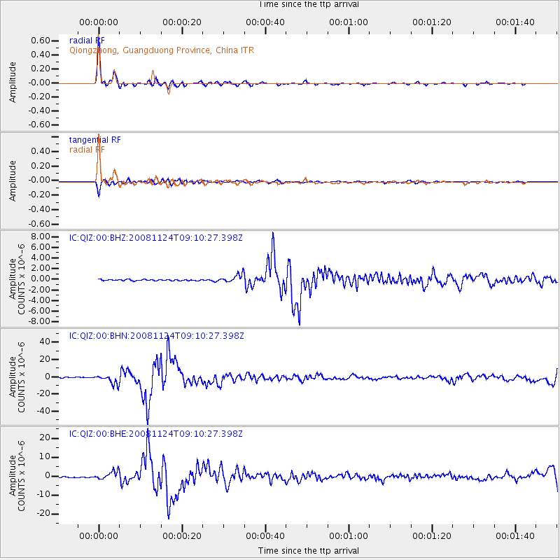
Signal To Noise
| Channel | StoN | STA | LTA |
| IC:QIZ:00:BHN:20081124T09:10:27.398Z | 10.052851 | 5.385293E-6 | 5.356981E-7 |
| IC:QIZ:00:BHE:20081124T09:10:27.398Z | 8.172115 | 2.2313297E-6 | 2.7304188E-7 |
| IC:QIZ:00:BHZ:20081124T09:10:27.398Z | 7.392999 | 8.038226E-7 | 1.0872754E-7 |
| Arrivals |
| Ps | 3.7 SECOND |
| PpPs | 9.5 SECOND |
| PsPs/PpSs | 13 SECOND |


