You are here: Home > Network List > IC - New China Digital Seismograph Network Stations List
> Station QIZ Qiongzhong, Guangduong Province, China > Earthquake Result Viewer
QIZ Qiongzhong, Guangduong Province, China - Earthquake Result Viewer

| Earthquake location: |
Southeast Of Honshu, Japan |
| Earthquake latitude/longitude: |
32.8/140.4 |
| Earthquake time(UTC): |
2009/08/12 (224) 22:48:51 GMT |
| Earthquake Depth: |
53 km |
| Earthquake Magnitude: |
6.2 MB, 6.6 MW, 6.6 MW |
| Earthquake Catalog/Contributor: |
WHDF/NEIC |
|
| Network: |
IC New China Digital Seismograph Network |
| Station: |
QIZ Qiongzhong, Guangduong Province, China |
| Lat/Lon: |
19.03 N/109.84 E |
| Elevation: |
230 m |
|
| Distance: |
30.6 deg |
| Az: |
250.893 deg |
| Baz: |
57.249 deg |
| Ray Param: |
0.07922214 |
| Estimated Moho Depth: |
38.75 km |
| Estimated Crust Vp/Vs: |
1.60 |
| Assumed Crust Vp: |
6.182 km/s |
| Estimated Crust Vs: |
3.858 km/s |
| Estimated Crust Poisson's Ratio: |
0.18 |
|
| Radial Match: |
96.13122 % |
| Radial Bump: |
245 |
| Transverse Match: |
90.96815 % |
| Transverse Bump: |
400 |
| SOD ConfigId: |
2622 |
| Insert Time: |
2010-03-04 23:33:32.034 +0000 |
| GWidth: |
2.5 |
| Max Bumps: |
400 |
| Tol: |
0.001 |
|
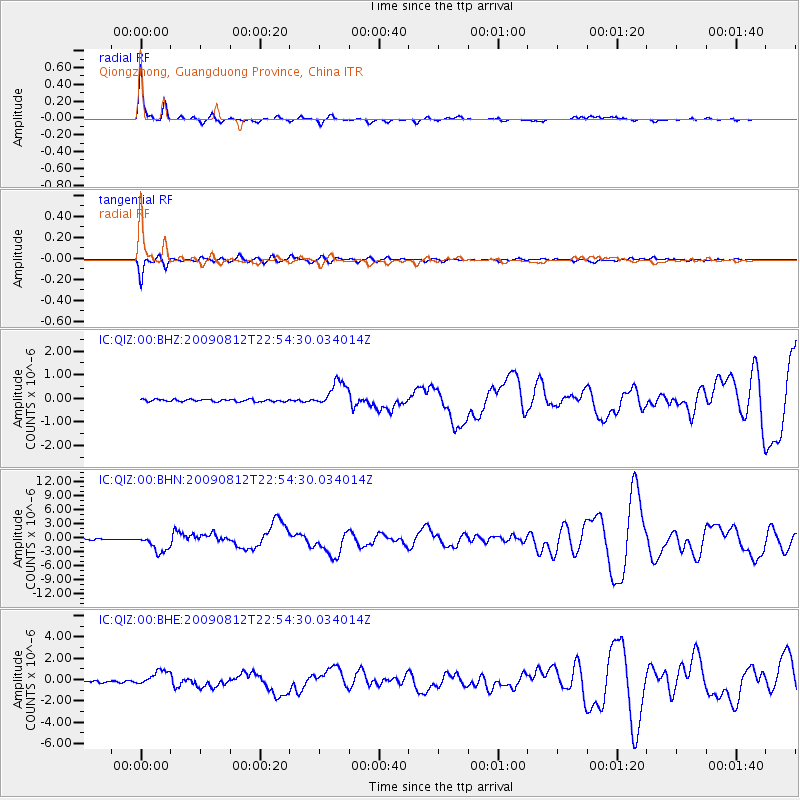
Signal To Noise
| Channel | StoN | STA | LTA |
| IC:QIZ:00:BHN:20090812T22:54:30.034014Z | 12.78964 | 1.886542E-6 | 1.4750547E-7 |
| IC:QIZ:00:BHE:20090812T22:54:30.034014Z | 7.9231524 | 7.2454526E-7 | 9.144659E-8 |
| IC:QIZ:00:BHZ:20090812T22:54:30.034014Z | 11.340909 | 5.455175E-7 | 4.8101743E-8 |
| Arrivals |
| Ps | 4.1 SECOND |
| PpPs | 15 SECOND |
| PsPs/PpSs | 19 SECOND |


