You are here: Home > Network List > CN - Canadian National Seismograph Network Stations List
> Station INK INUVIK, NT > Earthquake Result Viewer
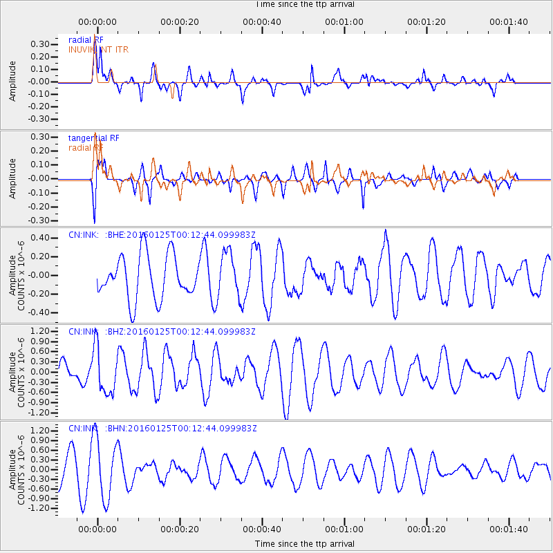
INK INUVIK, NT - Earthquake Result Viewer
*The percent match for this event was below the threshold and hence no stack was calculated.
| Earthquake location: |
Tonga Islands |
| Earthquake latitude/longitude: |
-19.6/-173.4 |
| Earthquake time(UTC): |
2016/01/25 (025) 00:00:09 GMT |
| Earthquake Depth: |
40 km |
| Earthquake Magnitude: |
5.7 MB |
| Earthquake Catalog/Contributor: |
NEIC PDE/NEIC COMCAT |
|
| Network: |
CN Canadian National Seismograph Network |
| Station: |
INK INUVIK, NT |
| Lat/Lon: |
68.31 N/133.53 W |
| Elevation: |
44 m |
|
| Distance: |
92.3 deg |
| Az: |
13.801 deg |
| Baz: |
217.222 deg |
| Ray Param: |
$rayparam |
*The percent match for this event was below the threshold and hence was not used in the summary stack. |
|
| Radial Match: |
51.8634 % |
| Radial Bump: |
346 |
| Transverse Match: |
51.37798 % |
| Transverse Bump: |
400 |
| SOD ConfigId: |
7422571 |
| Insert Time: |
2019-04-21 19:51:15.686 +0000 |
| GWidth: |
2.5 |
| Max Bumps: |
400 |
| Tol: |
0.001 |
|
Signal To Noise
| Channel | StoN | STA | LTA |
| CN:INK: :BHZ:20160125T00:12:44.099983Z | 2.1316288 | 6.997992E-7 | 3.282932E-7 |
| CN:INK: :BHN:20160125T00:12:44.099983Z | 1.6583183 | 9.468407E-7 | 5.7096446E-7 |
| CN:INK: :BHE:20160125T00:12:44.099983Z | 1.0436058 | 2.4350166E-7 | 2.3332723E-7 |
| Arrivals |
| Ps | |
| PpPs | |
| PsPs/PpSs | |


