You are here: Home > Network List > TA - USArray Transportable Network (new EarthScope stations) Stations List
> Station 121A Cookes Peak, Deming, NM, USA > Earthquake Result Viewer
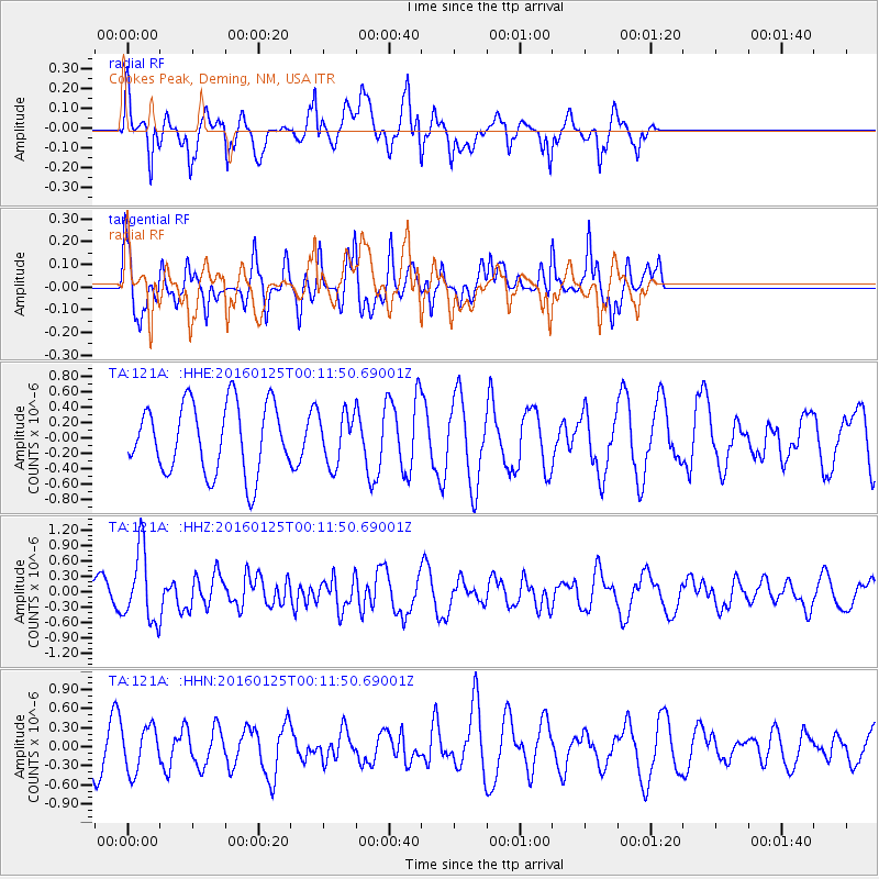
121A Cookes Peak, Deming, NM, USA - Earthquake Result Viewer
*The percent match for this event was below the threshold and hence no stack was calculated.
| Earthquake location: |
Tonga Islands |
| Earthquake latitude/longitude: |
-19.6/-173.4 |
| Earthquake time(UTC): |
2016/01/25 (025) 00:00:09 GMT |
| Earthquake Depth: |
40 km |
| Earthquake Magnitude: |
5.7 MB |
| Earthquake Catalog/Contributor: |
NEIC PDE/NEIC COMCAT |
|
| Network: |
TA USArray Transportable Network (new EarthScope stations) |
| Station: |
121A Cookes Peak, Deming, NM, USA |
| Lat/Lon: |
32.53 N/107.79 W |
| Elevation: |
1652 m |
|
| Distance: |
81.4 deg |
| Az: |
51.096 deg |
| Baz: |
240.29 deg |
| Ray Param: |
$rayparam |
*The percent match for this event was below the threshold and hence was not used in the summary stack. |
|
| Radial Match: |
71.951096 % |
| Radial Bump: |
299 |
| Transverse Match: |
60.52865 % |
| Transverse Bump: |
346 |
| SOD ConfigId: |
7422571 |
| Insert Time: |
2019-04-21 19:54:15.520 +0000 |
| GWidth: |
2.5 |
| Max Bumps: |
400 |
| Tol: |
0.001 |
|
Signal To Noise
| Channel | StoN | STA | LTA |
| TA:121A: :HHZ:20160125T00:11:50.69001Z | 2.863866 | 6.8938556E-7 | 2.407185E-7 |
| TA:121A: :HHN:20160125T00:11:50.69001Z | 1.0385784 | 3.4747524E-7 | 3.345681E-7 |
| TA:121A: :HHE:20160125T00:11:50.69001Z | 0.76297796 | 3.4051965E-7 | 4.463034E-7 |
| Arrivals |
| Ps | |
| PpPs | |
| PsPs/PpSs | |


