You are here: Home > Network List > NE - New England Seismic Network Stations List
> Station HNH Hanover, NH, USA > Earthquake Result Viewer
HNH Hanover, NH, USA - Earthquake Result Viewer
| Earthquake location: |
Kuril Islands |
| Earthquake latitude/longitude: |
44.0/147.9 |
| Earthquake time(UTC): |
2015/07/07 (188) 05:10:27 GMT |
| Earthquake Depth: |
38 km |
| Earthquake Magnitude: |
6.3 MO |
| Earthquake Catalog/Contributor: |
NEIC PDE/NEIC ALERT |
|
| Network: |
NE New England Seismic Network |
| Station: |
HNH Hanover, NH, USA |
| Lat/Lon: |
43.71 N/72.29 W |
| Elevation: |
180 m |
|
| Distance: |
85.6 deg |
| Az: |
28.015 deg |
| Baz: |
332.127 deg |
| Ray Param: |
0.044596445 |
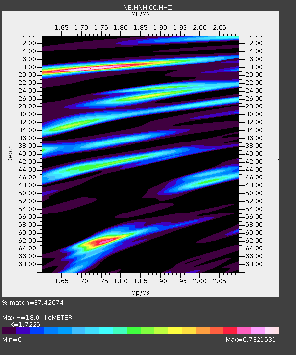
| Estimated Moho Depth: |
18.0 km |
| Estimated Crust Vp/Vs: |
1.72 |
| Assumed Crust Vp: |
6.419 km/s |
| Estimated Crust Vs: |
3.727 km/s |
| Estimated Crust Poisson's Ratio: |
0.25 |
|
| Radial Match: |
87.42074 % |
| Radial Bump: |
327 |
| Transverse Match: |
74.90468 % |
| Transverse Bump: |
400 |
| SOD ConfigId: |
976571 |
| Insert Time: |
2015-07-21 05:35:46.461 +0000 |
| GWidth: |
2.5 |
| Max Bumps: |
400 |
| Tol: |
0.001 |
|

Signal To Noise
| Channel | StoN | STA | LTA |
| NE:HNH:00:HHZ:20150707T05:22:30.423999Z | 10.345686 | 2.8897555E-6 | 2.7931986E-7 |
| NE:HNH:00:HH1:20150707T05:22:30.423999Z | 5.015938 | 9.1523424E-7 | 1.8246523E-7 |
| NE:HNH:00:HH2:20150707T05:22:30.423999Z | 4.713739 | 7.926111E-7 | 1.6814913E-7 |
| Arrivals |
| Ps | 2.1 SECOND |
| PpPs | 7.4 SECOND |
| PsPs/PpSs | 9.5 SECOND |


