You are here: Home > Network List > CI - Caltech Regional Seismic Network Stations List
> Station BAR Barrett, Tecate, CA, USA > Earthquake Result Viewer
BAR Barrett, Tecate, CA, USA - Earthquake Result Viewer
| Earthquake location: |
New Ireland Region, P.N.G. |
| Earthquake latitude/longitude: |
-4.0/152.2 |
| Earthquake time(UTC): |
2000/11/16 (321) 04:54:56 GMT |
| Earthquake Depth: |
33 km |
| Earthquake Magnitude: |
6.0 MB, 8.2 MS, 8.0 MW, 8.0 ME |
| Earthquake Catalog/Contributor: |
WHDF/NEIC |
|
| Network: |
CI Caltech Regional Seismic Network |
| Station: |
BAR Barrett, Tecate, CA, USA |
| Lat/Lon: |
32.68 N/116.67 W |
| Elevation: |
521 m |
|
| Distance: |
93.1 deg |
| Az: |
57.608 deg |
| Baz: |
267.285 deg |
| Ray Param: |
0.041316804 |
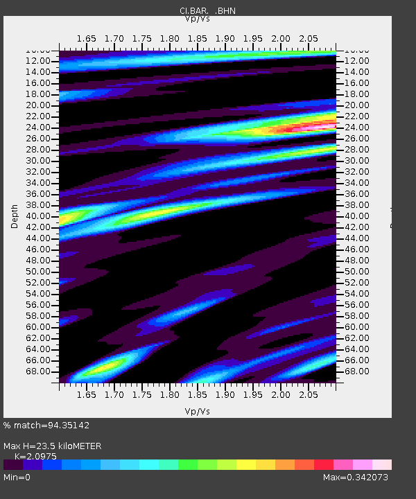
| Estimated Moho Depth: |
23.5 km |
| Estimated Crust Vp/Vs: |
2.10 |
| Assumed Crust Vp: |
6.264 km/s |
| Estimated Crust Vs: |
2.986 km/s |
| Estimated Crust Poisson's Ratio: |
0.35 |
|
| Radial Match: |
94.35142 % |
| Radial Bump: |
257 |
| Transverse Match: |
67.309525 % |
| Transverse Bump: |
400 |
| SOD ConfigId: |
3770 |
| Insert Time: |
2010-02-26 00:05:37.927 +0000 |
| GWidth: |
2.5 |
| Max Bumps: |
400 |
| Tol: |
0.001 |
|
Signal To Noise
| Channel | StoN | STA | LTA |
| CI:BAR: :BHN:20001116T05:07:35.937021Z | 0.872586 | 1.5998046E-7 | 1.8334062E-7 |
| CI:BAR: :BHE:20001116T05:07:35.937021Z | 0.8559773 | 1.5348834E-7 | 1.7931357E-7 |
| CI:BAR: :BHZ:20001116T05:07:35.937021Z | 0.9615076 | 2.3384227E-7 | 2.4320377E-7 |
| Arrivals |
| Ps | 4.2 SECOND |
| PpPs | 11 SECOND |
| PsPs/PpSs | 16 SECOND |


