You are here: Home > Network List > AF - Africa Array Stations List
> Station DODT Dodoma, Tanzania > Earthquake Result Viewer
DODT Dodoma, Tanzania - Earthquake Result Viewer
| Earthquake location: |
Strait Of Gibraltar |
| Earthquake latitude/longitude: |
35.7/-3.6 |
| Earthquake time(UTC): |
2016/01/25 (025) 04:22:02 GMT |
| Earthquake Depth: |
10 km |
| Earthquake Magnitude: |
6.1 MWP |
| Earthquake Catalog/Contributor: |
NEIC PDE/NEIC COMCAT |
|
| Network: |
AF Africa Array |
| Station: |
DODT Dodoma, Tanzania |
| Lat/Lon: |
6.19 S/35.75 E |
| Elevation: |
1114 m |
|
| Distance: |
55.7 deg |
| Az: |
130.281 deg |
| Baz: |
321.376 deg |
| Ray Param: |
0.06461093 |
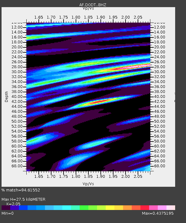
| Estimated Moho Depth: |
27.5 km |
| Estimated Crust Vp/Vs: |
2.05 |
| Assumed Crust Vp: |
6.65 km/s |
| Estimated Crust Vs: |
3.244 km/s |
| Estimated Crust Poisson's Ratio: |
0.34 |
|
| Radial Match: |
94.61552 % |
| Radial Bump: |
389 |
| Transverse Match: |
83.277626 % |
| Transverse Bump: |
400 |
| SOD ConfigId: |
7422571 |
| Insert Time: |
2019-04-21 19:57:08.299 +0000 |
| GWidth: |
2.5 |
| Max Bumps: |
400 |
| Tol: |
0.001 |
|

Signal To Noise
| Channel | StoN | STA | LTA |
| AF:DODT: :BHZ:20160125T04:31:07.900002Z | 1.0794567 | 1.3931995E-13 | 1.2906488E-13 |
| AF:DODT: :BHN:20160125T04:31:07.900002Z | 0.9292804 | 5.6301108E-14 | 6.0585705E-14 |
| AF:DODT: :BHE:20160125T04:31:07.900002Z | 0.86078954 | 3.5841586E-14 | 4.163804E-14 |
| Arrivals |
| Ps | 4.6 SECOND |
| PpPs | 12 SECOND |
| PsPs/PpSs | 17 SECOND |


