You are here: Home > Network List > C1 - Red Sismologica Nacional Stations List
> Station AP01 Chacalluta > Earthquake Result Viewer
AP01 Chacalluta - Earthquake Result Viewer
| Earthquake location: |
Strait Of Gibraltar |
| Earthquake latitude/longitude: |
35.7/-3.6 |
| Earthquake time(UTC): |
2016/01/25 (025) 04:22:02 GMT |
| Earthquake Depth: |
10 km |
| Earthquake Magnitude: |
6.1 MWP |
| Earthquake Catalog/Contributor: |
NEIC PDE/NEIC COMCAT |
|
| Network: |
C1 Red Sismologica Nacional |
| Station: |
AP01 Chacalluta |
| Lat/Lon: |
18.37 S/70.34 W |
| Elevation: |
21 m |
|
| Distance: |
82.9 deg |
| Az: |
241.543 deg |
| Baz: |
48.863 deg |
| Ray Param: |
0.046536546 |
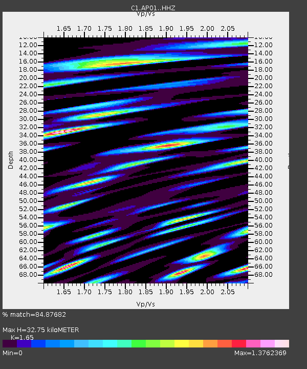
| Estimated Moho Depth: |
32.75 km |
| Estimated Crust Vp/Vs: |
1.65 |
| Assumed Crust Vp: |
4.24 km/s |
| Estimated Crust Vs: |
2.57 km/s |
| Estimated Crust Poisson's Ratio: |
0.21 |
|
| Radial Match: |
84.87682 % |
| Radial Bump: |
400 |
| Transverse Match: |
68.04128 % |
| Transverse Bump: |
400 |
| SOD ConfigId: |
7422571 |
| Insert Time: |
2019-04-21 19:58:01.876 +0000 |
| GWidth: |
2.5 |
| Max Bumps: |
400 |
| Tol: |
0.001 |
|

Signal To Noise
| Channel | StoN | STA | LTA |
| C1:AP01: :HHZ:20160125T04:33:55.400002Z | 1.9243666 | 2.2796462E-6 | 1.1846216E-6 |
| C1:AP01: :HHN:20160125T04:33:55.400002Z | 2.0997045 | 2.3760174E-6 | 1.1315962E-6 |
| C1:AP01: :HHE:20160125T04:33:55.400002Z | 2.0261614 | 1.5885277E-6 | 7.840084E-7 |
| Arrivals |
| Ps | 5.1 SECOND |
| PpPs | 20 SECOND |
| PsPs/PpSs | 25 SECOND |


