You are here: Home > Network List > CN - Canadian National Seismograph Network Stations List
> Station FRB IQALUIT, N.W.T. > Earthquake Result Viewer
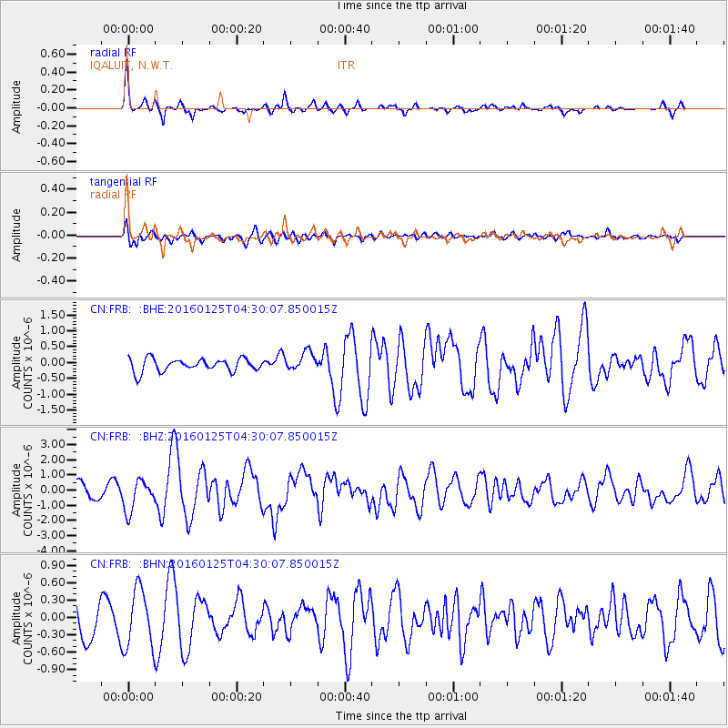
FRB IQALUIT, N.W.T. - Earthquake Result Viewer
*The percent match for this event was below the threshold and hence no stack was calculated.
| Earthquake location: |
Strait Of Gibraltar |
| Earthquake latitude/longitude: |
35.7/-3.6 |
| Earthquake time(UTC): |
2016/01/25 (025) 04:22:02 GMT |
| Earthquake Depth: |
10 km |
| Earthquake Magnitude: |
6.1 MWP |
| Earthquake Catalog/Contributor: |
NEIC PDE/NEIC COMCAT |
|
| Network: |
CN Canadian National Seismograph Network |
| Station: |
FRB IQALUIT, N.W.T. |
| Lat/Lon: |
63.75 N/68.55 W |
| Elevation: |
18 m |
|
| Distance: |
47.6 deg |
| Az: |
326.946 deg |
| Baz: |
93.873 deg |
| Ray Param: |
$rayparam |
*The percent match for this event was below the threshold and hence was not used in the summary stack. |
|
| Radial Match: |
78.97959 % |
| Radial Bump: |
276 |
| Transverse Match: |
62.352844 % |
| Transverse Bump: |
400 |
| SOD ConfigId: |
7422571 |
| Insert Time: |
2019-04-21 19:58:53.323 +0000 |
| GWidth: |
2.5 |
| Max Bumps: |
400 |
| Tol: |
0.001 |
|
Signal To Noise
| Channel | StoN | STA | LTA |
| CN:FRB: :BHZ:20160125T04:30:07.850015Z | 2.197768 | 1.033293E-6 | 4.701556E-7 |
| CN:FRB: :BHN:20160125T04:30:07.850015Z | 1.6215744 | 5.013206E-7 | 3.091567E-7 |
| CN:FRB: :BHE:20160125T04:30:07.850015Z | 1.5039632 | 2.9751388E-7 | 1.978199E-7 |
| Arrivals |
| Ps | |
| PpPs | |
| PsPs/PpSs | |


