You are here: Home > Network List > NX - Nanometrics Research Network Stations List
> Station STN15 Seismic station 15 > Earthquake Result Viewer
STN15 Seismic station 15 - Earthquake Result Viewer
| Earthquake location: |
Strait Of Gibraltar |
| Earthquake latitude/longitude: |
35.7/-3.6 |
| Earthquake time(UTC): |
2016/01/25 (025) 04:22:02 GMT |
| Earthquake Depth: |
10 km |
| Earthquake Magnitude: |
6.1 MWP |
| Earthquake Catalog/Contributor: |
NEIC PDE/NEIC COMCAT |
|
| Network: |
NX Nanometrics Research Network |
| Station: |
STN15 Seismic station 15 |
| Lat/Lon: |
36.35 N/97.37 W |
| Elevation: |
316 m |
|
| Distance: |
72.5 deg |
| Az: |
302.389 deg |
| Baz: |
58.313 deg |
| Ray Param: |
0.053587947 |
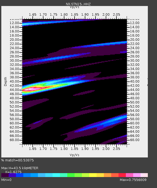
| Estimated Moho Depth: |
43.5 km |
| Estimated Crust Vp/Vs: |
1.63 |
| Assumed Crust Vp: |
6.483 km/s |
| Estimated Crust Vs: |
3.983 km/s |
| Estimated Crust Poisson's Ratio: |
0.20 |
|
| Radial Match: |
80.53875 % |
| Radial Bump: |
342 |
| Transverse Match: |
54.603947 % |
| Transverse Bump: |
400 |
| SOD ConfigId: |
7422571 |
| Insert Time: |
2019-04-21 20:01:57.075 +0000 |
| GWidth: |
2.5 |
| Max Bumps: |
400 |
| Tol: |
0.001 |
|

Signal To Noise
| Channel | StoN | STA | LTA |
| NX:STN15: :HHZ:20160125T04:32:58.150002Z | 4.494825 | 1.1314314E-6 | 2.517187E-7 |
| NX:STN15: :HH1:20160125T04:32:58.150002Z | 1.5806009 | 5.446274E-7 | 3.4456988E-7 |
| NX:STN15: :HH2:20160125T04:32:58.150002Z | 1.7555803 | 7.7577494E-7 | 4.4189088E-7 |
| Arrivals |
| Ps | 4.4 SECOND |
| PpPs | 17 SECOND |
| PsPs/PpSs | 21 SECOND |


