You are here: Home > Network List > CI - Caltech Regional Seismic Network Stations List
> Station BAR Barrett, Tecate, CA, USA > Earthquake Result Viewer
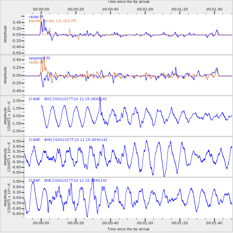
BAR Barrett, Tecate, CA, USA - Earthquake Result Viewer
| Earthquake location: |
Leeward Islands |
| Earthquake latitude/longitude: |
17.6/-61.2 |
| Earthquake time(UTC): |
2000/10/27 (301) 19:02:52 GMT |
| Earthquake Depth: |
38 km |
| Earthquake Magnitude: |
5.4 MB, 5.3 MS, 5.8 MW, 5.6 MW |
| Earthquake Catalog/Contributor: |
WHDF/NEIC |
|
| Network: |
CI Caltech Regional Seismic Network |
| Station: |
BAR Barrett, Tecate, CA, USA |
| Lat/Lon: |
32.68 N/116.67 W |
| Elevation: |
521 m |
|
| Distance: |
51.9 deg |
| Az: |
297.966 deg |
| Baz: |
92.699 deg |
| Ray Param: |
0.06704316 |
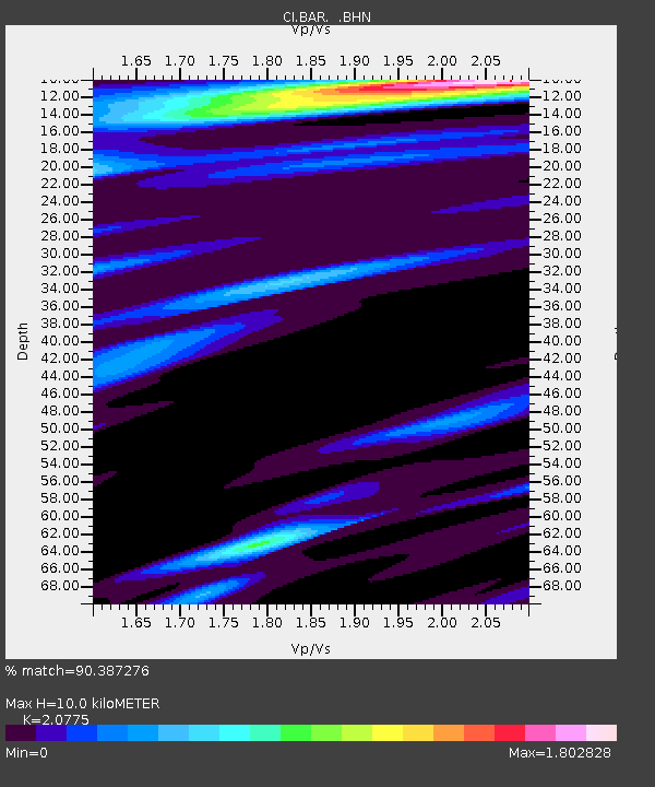
| Estimated Moho Depth: |
10.0 km |
| Estimated Crust Vp/Vs: |
2.08 |
| Assumed Crust Vp: |
6.264 km/s |
| Estimated Crust Vs: |
3.015 km/s |
| Estimated Crust Poisson's Ratio: |
0.35 |
|
| Radial Match: |
90.387276 % |
| Radial Bump: |
400 |
| Transverse Match: |
72.68671 % |
| Transverse Bump: |
400 |
| SOD ConfigId: |
3770 |
| Insert Time: |
2010-02-26 00:05:38.763 +0000 |
| GWidth: |
2.5 |
| Max Bumps: |
400 |
| Tol: |
0.001 |
|
Signal To Noise
| Channel | StoN | STA | LTA |
| CI:BAR: :BHN:20001027T19:11:26.984014Z | 0.88069695 | 2.467153E-7 | 2.8013642E-7 |
| CI:BAR: :BHE:20001027T19:11:26.984014Z | 0.7190505 | 4.4420472E-7 | 6.1776564E-7 |
| CI:BAR: :BHZ:20001027T19:11:26.984014Z | 0.97056127 | 9.354829E-7 | 9.638577E-7 |
| Arrivals |
| Ps | 1.8 SECOND |
| PpPs | 4.7 SECOND |
| PsPs/PpSs | 6.5 SECOND |


