You are here: Home > Network List > RV - Regional Alberta Seismic Observatory for Earthquake Studies Network Stations List
> Station WTMTA White Mountain Lookout Tower, AB > Earthquake Result Viewer
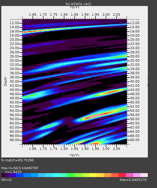
WTMTA White Mountain Lookout Tower, AB - Earthquake Result Viewer
| Earthquake location: |
Strait Of Gibraltar |
| Earthquake latitude/longitude: |
35.7/-3.6 |
| Earthquake time(UTC): |
2016/01/25 (025) 04:22:02 GMT |
| Earthquake Depth: |
10 km |
| Earthquake Magnitude: |
6.1 MWP |
| Earthquake Catalog/Contributor: |
NEIC PDE/NEIC COMCAT |
|
| Network: |
RV Regional Alberta Seismic Observatory for Earthquake Studies Network |
| Station: |
WTMTA White Mountain Lookout Tower, AB |
| Lat/Lon: |
55.69 N/119.24 W |
| Elevation: |
1030 m |
|
| Distance: |
73.7 deg |
| Az: |
327.88 deg |
| Baz: |
49.815 deg |
| Ray Param: |
0.052803226 |
| Estimated Moho Depth: |
56.5 km |
| Estimated Crust Vp/Vs: |
1.94 |
| Assumed Crust Vp: |
6.161 km/s |
| Estimated Crust Vs: |
3.172 km/s |
| Estimated Crust Poisson's Ratio: |
0.32 |
|
| Radial Match: |
85.75298 % |
| Radial Bump: |
354 |
| Transverse Match: |
59.765198 % |
| Transverse Bump: |
400 |
| SOD ConfigId: |
7422571 |
| Insert Time: |
2019-04-21 20:03:14.694 +0000 |
| GWidth: |
2.5 |
| Max Bumps: |
400 |
| Tol: |
0.001 |
|

Signal To Noise
| Channel | StoN | STA | LTA |
| RV:WTMTA: :HHZ:20160125T04:33:05.47001Z | 2.8205073 | 9.752143E-7 | 3.4575848E-7 |
| RV:WTMTA: :HHN:20160125T04:33:05.47001Z | 1.4469064 | 9.5288107E-7 | 6.585644E-7 |
| RV:WTMTA: :HHE:20160125T04:33:05.47001Z | 0.71738666 | 3.961169E-7 | 5.521665E-7 |
| Arrivals |
| Ps | 8.9 SECOND |
| PpPs | 26 SECOND |
| PsPs/PpSs | 35 SECOND |


