You are here: Home > Network List > TA - USArray Transportable Network (new EarthScope stations) Stations List
> Station KMSC Kings Mountain, Blacksburg, SC, USA > Earthquake Result Viewer
KMSC Kings Mountain, Blacksburg, SC, USA - Earthquake Result Viewer
| Earthquake location: |
Strait Of Gibraltar |
| Earthquake latitude/longitude: |
35.7/-3.6 |
| Earthquake time(UTC): |
2016/01/25 (025) 04:22:02 GMT |
| Earthquake Depth: |
10 km |
| Earthquake Magnitude: |
6.1 MWP |
| Earthquake Catalog/Contributor: |
NEIC PDE/NEIC COMCAT |
|
| Network: |
TA USArray Transportable Network (new EarthScope stations) |
| Station: |
KMSC Kings Mountain, Blacksburg, SC, USA |
| Lat/Lon: |
35.14 N/81.33 W |
| Elevation: |
240 m |
|
| Distance: |
61.7 deg |
| Az: |
294.498 deg |
| Baz: |
64.594 deg |
| Ray Param: |
0.06073845 |
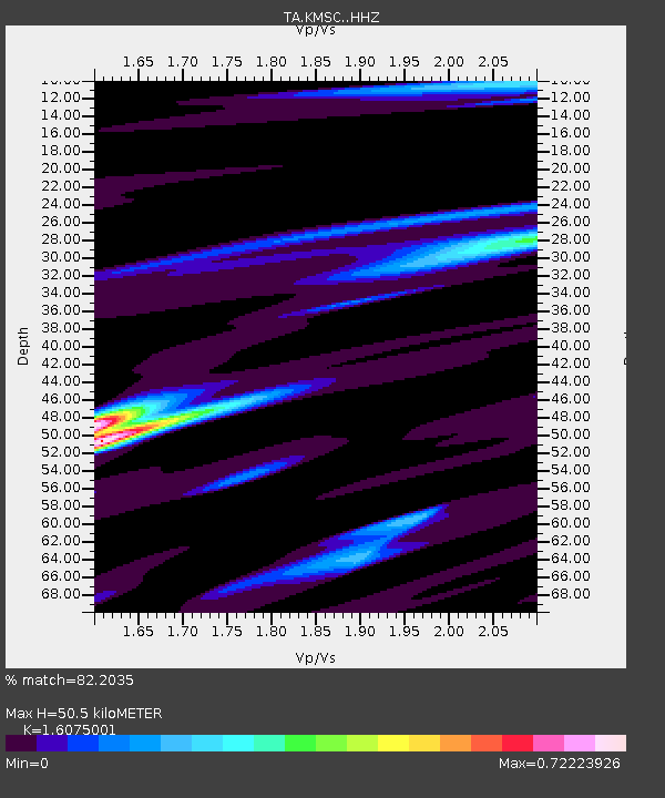
| Estimated Moho Depth: |
50.5 km |
| Estimated Crust Vp/Vs: |
1.61 |
| Assumed Crust Vp: |
6.419 km/s |
| Estimated Crust Vs: |
3.993 km/s |
| Estimated Crust Poisson's Ratio: |
0.18 |
|
| Radial Match: |
82.2035 % |
| Radial Bump: |
305 |
| Transverse Match: |
57.55854 % |
| Transverse Bump: |
315 |
| SOD ConfigId: |
7422571 |
| Insert Time: |
2019-04-21 20:03:32.046 +0000 |
| GWidth: |
2.5 |
| Max Bumps: |
400 |
| Tol: |
0.001 |
|

Signal To Noise
| Channel | StoN | STA | LTA |
| TA:KMSC: :HHZ:20160125T04:31:48.999978Z | 1.5133315 | 8.3193777E-7 | 5.4973924E-7 |
| TA:KMSC: :HHN:20160125T04:31:48.999978Z | 0.8265215 | 2.902368E-7 | 3.511546E-7 |
| TA:KMSC: :HHE:20160125T04:31:48.999978Z | 0.9360672 | 4.225533E-7 | 4.5141343E-7 |
| Arrivals |
| Ps | 5.0 SECOND |
| PpPs | 20 SECOND |
| PsPs/PpSs | 25 SECOND |


