You are here: Home > Network List > TA - USArray Transportable Network (new EarthScope stations) Stations List
> Station MDND Maddock, ND, USA > Earthquake Result Viewer
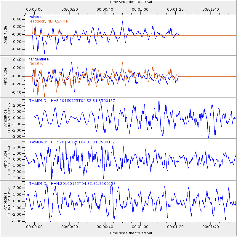
MDND Maddock, ND, USA - Earthquake Result Viewer
*The percent match for this event was below the threshold and hence no stack was calculated.
| Earthquake location: |
Strait Of Gibraltar |
| Earthquake latitude/longitude: |
35.7/-3.6 |
| Earthquake time(UTC): |
2016/01/25 (025) 04:22:02 GMT |
| Earthquake Depth: |
10 km |
| Earthquake Magnitude: |
6.1 MWP |
| Earthquake Catalog/Contributor: |
NEIC PDE/NEIC COMCAT |
|
| Network: |
TA USArray Transportable Network (new EarthScope stations) |
| Station: |
MDND Maddock, ND, USA |
| Lat/Lon: |
47.85 N/99.60 W |
| Elevation: |
479 m |
|
| Distance: |
68.1 deg |
| Az: |
313.795 deg |
| Baz: |
60.668 deg |
| Ray Param: |
$rayparam |
*The percent match for this event was below the threshold and hence was not used in the summary stack. |
|
| Radial Match: |
55.733208 % |
| Radial Bump: |
342 |
| Transverse Match: |
63.578922 % |
| Transverse Bump: |
400 |
| SOD ConfigId: |
7422571 |
| Insert Time: |
2019-04-21 20:03:36.574 +0000 |
| GWidth: |
2.5 |
| Max Bumps: |
400 |
| Tol: |
0.001 |
|
Signal To Noise
| Channel | StoN | STA | LTA |
| TA:MDND: :HHZ:20160125T04:32:31.350015Z | 2.0561526 | 7.149644E-7 | 3.4771952E-7 |
| TA:MDND: :HHN:20160125T04:32:31.350015Z | 0.9433579 | 8.060695E-7 | 8.544684E-7 |
| TA:MDND: :HHE:20160125T04:32:31.350015Z | 1.2583938 | 9.640129E-7 | 7.6606614E-7 |
| Arrivals |
| Ps | |
| PpPs | |
| PsPs/PpSs | |


