You are here: Home > Network List > TJ - Tajikistan National Seismic Network Stations List
> Station SHAA Shaartuz, Tajikistan > Earthquake Result Viewer
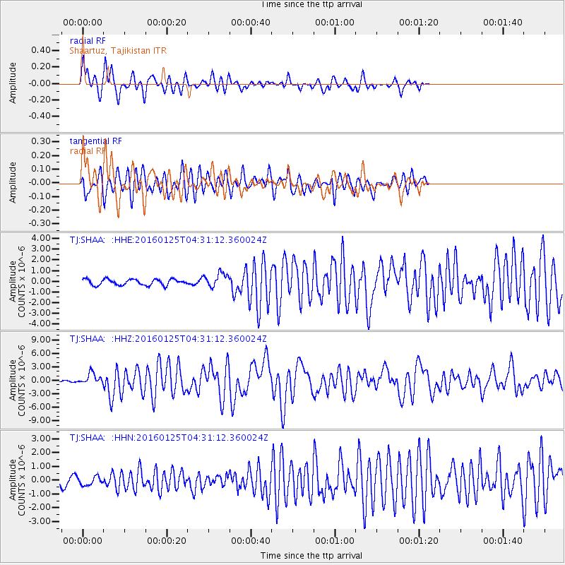
SHAA Shaartuz, Tajikistan - Earthquake Result Viewer
*The percent match for this event was below the threshold and hence no stack was calculated.
| Earthquake location: |
Strait Of Gibraltar |
| Earthquake latitude/longitude: |
35.7/-3.6 |
| Earthquake time(UTC): |
2016/01/25 (025) 04:22:02 GMT |
| Earthquake Depth: |
10 km |
| Earthquake Magnitude: |
6.1 MWP |
| Earthquake Catalog/Contributor: |
NEIC PDE/NEIC COMCAT |
|
| Network: |
TJ Tajikistan National Seismic Network |
| Station: |
SHAA Shaartuz, Tajikistan |
| Lat/Lon: |
37.56 N/68.12 E |
| Elevation: |
868 m |
|
| Distance: |
56.2 deg |
| Az: |
65.185 deg |
| Baz: |
291.688 deg |
| Ray Param: |
$rayparam |
*The percent match for this event was below the threshold and hence was not used in the summary stack. |
|
| Radial Match: |
79.126205 % |
| Radial Bump: |
400 |
| Transverse Match: |
76.226265 % |
| Transverse Bump: |
400 |
| SOD ConfigId: |
7422571 |
| Insert Time: |
2019-04-21 20:04:02.731 +0000 |
| GWidth: |
2.5 |
| Max Bumps: |
400 |
| Tol: |
0.001 |
|
Signal To Noise
| Channel | StoN | STA | LTA |
| TJ:SHAA: :HHZ:20160125T04:31:12.360024Z | 9.504722 | 1.2857925E-6 | 1.3527934E-7 |
| TJ:SHAA: :HHN:20160125T04:31:12.360024Z | 1.0735013 | 3.0954004E-7 | 2.8834623E-7 |
| TJ:SHAA: :HHE:20160125T04:31:12.360024Z | 2.3036923 | 6.4980867E-7 | 2.8207268E-7 |
| Arrivals |
| Ps | |
| PpPs | |
| PsPs/PpSs | |


