You are here: Home > Network List > NM - Cooperative New Madrid Seismic Network Stations List
> Station EUAL Eutaw, AL > Earthquake Result Viewer
EUAL Eutaw, AL - Earthquake Result Viewer
| Earthquake location: |
Kuril Islands |
| Earthquake latitude/longitude: |
44.0/147.9 |
| Earthquake time(UTC): |
2015/07/07 (188) 05:10:27 GMT |
| Earthquake Depth: |
38 km |
| Earthquake Magnitude: |
6.3 MO |
| Earthquake Catalog/Contributor: |
NEIC PDE/NEIC ALERT |
|
| Network: |
NM Cooperative New Madrid Seismic Network |
| Station: |
EUAL Eutaw, AL |
| Lat/Lon: |
32.97 N/88.09 W |
| Elevation: |
76 m |
|
| Distance: |
88.0 deg |
| Az: |
44.229 deg |
| Baz: |
323.204 deg |
| Ray Param: |
0.042894065 |
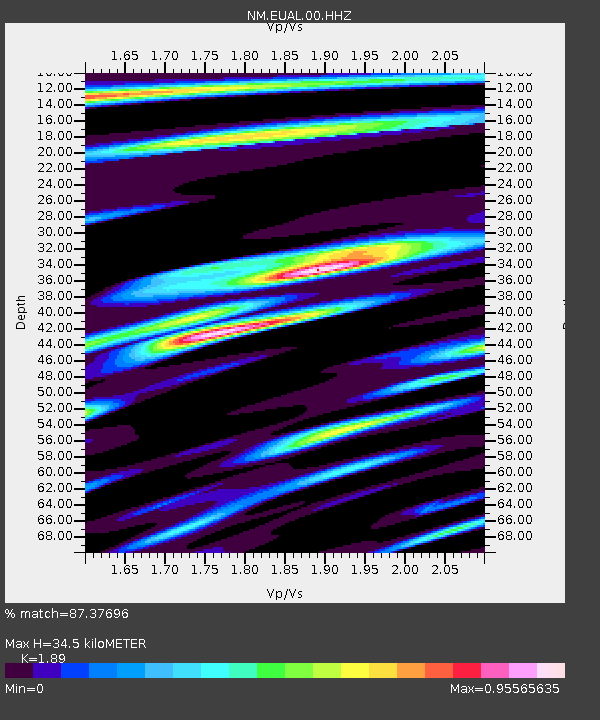
| Estimated Moho Depth: |
34.5 km |
| Estimated Crust Vp/Vs: |
1.89 |
| Assumed Crust Vp: |
6.201 km/s |
| Estimated Crust Vs: |
3.281 km/s |
| Estimated Crust Poisson's Ratio: |
0.31 |
|
| Radial Match: |
87.37696 % |
| Radial Bump: |
400 |
| Transverse Match: |
89.33802 % |
| Transverse Bump: |
360 |
| SOD ConfigId: |
976571 |
| Insert Time: |
2015-07-21 05:37:14.414 +0000 |
| GWidth: |
2.5 |
| Max Bumps: |
400 |
| Tol: |
0.001 |
|

Signal To Noise
| Channel | StoN | STA | LTA |
| NM:EUAL:00:HHZ:20150707T05:22:41.869983Z | 68.19756 | 4.011381E-6 | 5.8820003E-8 |
| NM:EUAL:00:HHN:20150707T05:22:41.869983Z | 8.824697 | 1.2342583E-6 | 1.398641E-7 |
| NM:EUAL:00:HHE:20150707T05:22:41.869983Z | 6.7384768 | 8.5469986E-7 | 1.2683874E-7 |
| Arrivals |
| Ps | 5.0 SECOND |
| PpPs | 16 SECOND |
| PsPs/PpSs | 21 SECOND |


