You are here: Home > Network List > XQ15 - Rapid response to the Mw 7.9 earthquake of April 25, 2015 in Nepal Stations List
> Station NA360 Katmandu,Nepal > Earthquake Result Viewer
NA360 Katmandu,Nepal - Earthquake Result Viewer
| Earthquake location: |
Strait Of Gibraltar |
| Earthquake latitude/longitude: |
35.7/-3.6 |
| Earthquake time(UTC): |
2016/01/25 (025) 04:22:02 GMT |
| Earthquake Depth: |
10 km |
| Earthquake Magnitude: |
6.1 MWP |
| Earthquake Catalog/Contributor: |
NEIC PDE/NEIC COMCAT |
|
| Network: |
XQ Rapid response to the Mw 7.9 earthquake of April 25, 2015 in Nepal |
| Station: |
NA360 Katmandu,Nepal |
| Lat/Lon: |
27.27 N/85.70 E |
| Elevation: |
274 m |
|
| Distance: |
74.1 deg |
| Az: |
67.733 deg |
| Baz: |
302.24 deg |
| Ray Param: |
0.052560948 |
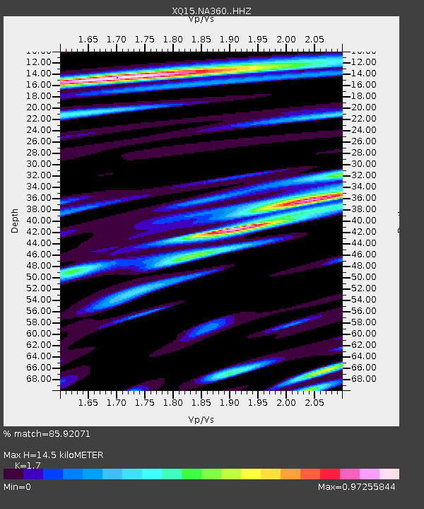
| Estimated Moho Depth: |
14.5 km |
| Estimated Crust Vp/Vs: |
1.70 |
| Assumed Crust Vp: |
6.142 km/s |
| Estimated Crust Vs: |
3.613 km/s |
| Estimated Crust Poisson's Ratio: |
0.24 |
|
| Radial Match: |
85.92071 % |
| Radial Bump: |
400 |
| Transverse Match: |
84.52034 % |
| Transverse Bump: |
400 |
| SOD ConfigId: |
7422571 |
| Insert Time: |
2019-04-21 20:05:41.657 +0000 |
| GWidth: |
2.5 |
| Max Bumps: |
400 |
| Tol: |
0.001 |
|

Signal To Noise
| Channel | StoN | STA | LTA |
| XQ:NA360: :HHZ:20160125T04:33:07.905007Z | 9.831194 | 6.4054694E-7 | 6.5154545E-8 |
| XQ:NA360: :HH1:20160125T04:33:07.905007Z | 1.5722033 | 1.9432493E-7 | 1.2360037E-7 |
| XQ:NA360: :HH2:20160125T04:33:07.905007Z | 0.8755474 | 2.1748095E-7 | 2.4839426E-7 |
| Arrivals |
| Ps | 1.7 SECOND |
| PpPs | 6.2 SECOND |
| PsPs/PpSs | 7.9 SECOND |


