You are here: Home > Network List > KN - Kyrgyz Seismic Telemetry Network Stations List
> Station TKM2 - > Earthquake Result Viewer
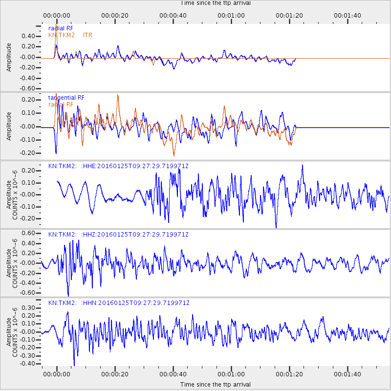
TKM2 - - Earthquake Result Viewer
*The percent match for this event was below the threshold and hence no stack was calculated.
| Earthquake location: |
North Of Halmahera, Indonesia |
| Earthquake latitude/longitude: |
3.2/128.4 |
| Earthquake time(UTC): |
2016/01/25 (025) 09:17:51 GMT |
| Earthquake Depth: |
52 km |
| Earthquake Magnitude: |
5.7 MB |
| Earthquake Catalog/Contributor: |
NEIC PDE/NEIC ALERT |
|
| Network: |
KN Kyrgyz Seismic Telemetry Network |
| Station: |
TKM2 - |
| Lat/Lon: |
42.92 N/75.60 E |
| Elevation: |
2020 m |
|
| Distance: |
61.2 deg |
| Az: |
318.148 deg |
| Baz: |
114.917 deg |
| Ray Param: |
$rayparam |
*The percent match for this event was below the threshold and hence was not used in the summary stack. |
|
| Radial Match: |
45.630424 % |
| Radial Bump: |
400 |
| Transverse Match: |
50.42706 % |
| Transverse Bump: |
400 |
| SOD ConfigId: |
7422571 |
| Insert Time: |
2019-04-21 20:08:25.130 +0000 |
| GWidth: |
2.5 |
| Max Bumps: |
400 |
| Tol: |
0.001 |
|
Signal To Noise
| Channel | StoN | STA | LTA |
| KN:TKM2: :HHZ:20160125T09:27:29.719971Z | 4.833778 | 2.5010124E-7 | 5.1740322E-8 |
| KN:TKM2: :HHN:20160125T09:27:29.719971Z | 2.7840183 | 1.1889898E-7 | 4.2707686E-8 |
| KN:TKM2: :HHE:20160125T09:27:29.719971Z | 1.2202423 | 7.365799E-8 | 6.036342E-8 |
| Arrivals |
| Ps | |
| PpPs | |
| PsPs/PpSs | |


