You are here: Home > Network List > TA - USArray Transportable Network (new EarthScope stations) Stations List
> Station I23K Minto, Yukon-Koyukuk, AK, USA > Earthquake Result Viewer
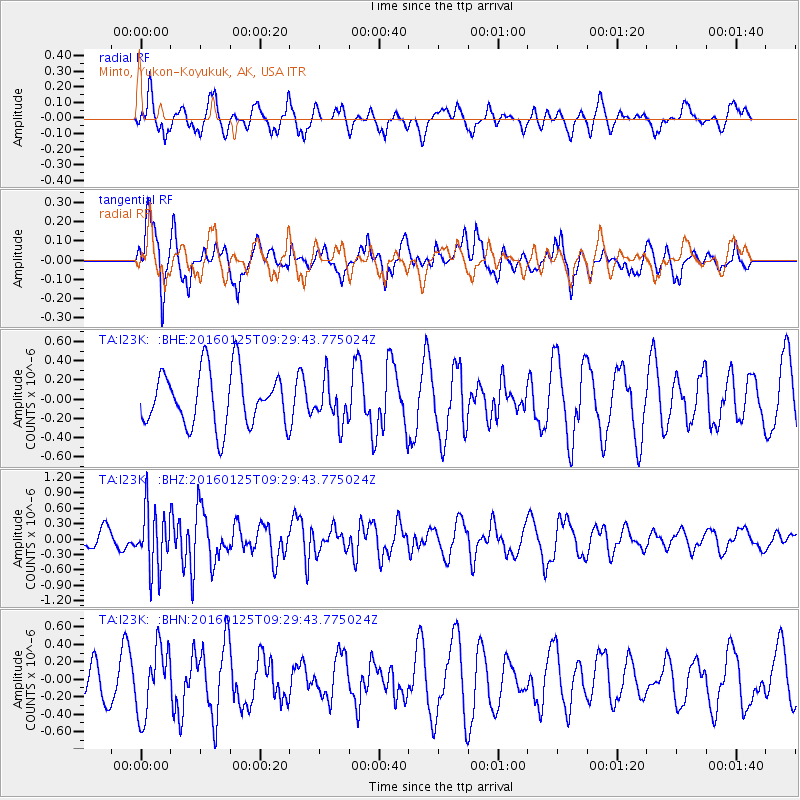
I23K Minto, Yukon-Koyukuk, AK, USA - Earthquake Result Viewer
*The percent match for this event was below the threshold and hence no stack was calculated.
| Earthquake location: |
North Of Halmahera, Indonesia |
| Earthquake latitude/longitude: |
3.2/128.4 |
| Earthquake time(UTC): |
2016/01/25 (025) 09:17:51 GMT |
| Earthquake Depth: |
52 km |
| Earthquake Magnitude: |
5.7 MB |
| Earthquake Catalog/Contributor: |
NEIC PDE/NEIC ALERT |
|
| Network: |
TA USArray Transportable Network (new EarthScope stations) |
| Station: |
I23K Minto, Yukon-Koyukuk, AK, USA |
| Lat/Lon: |
65.15 N/149.36 W |
| Elevation: |
149 m |
|
| Distance: |
83.9 deg |
| Az: |
24.909 deg |
| Baz: |
264.322 deg |
| Ray Param: |
$rayparam |
*The percent match for this event was below the threshold and hence was not used in the summary stack. |
|
| Radial Match: |
63.690994 % |
| Radial Bump: |
374 |
| Transverse Match: |
45.699993 % |
| Transverse Bump: |
400 |
| SOD ConfigId: |
7422571 |
| Insert Time: |
2019-04-21 20:09:06.774 +0000 |
| GWidth: |
2.5 |
| Max Bumps: |
400 |
| Tol: |
0.001 |
|
Signal To Noise
| Channel | StoN | STA | LTA |
| TA:I23K: :BHZ:20160125T09:29:43.775024Z | 2.652596 | 5.857569E-7 | 2.2082402E-7 |
| TA:I23K: :BHN:20160125T09:29:43.775024Z | 1.5680771 | 3.8853662E-7 | 2.47779E-7 |
| TA:I23K: :BHE:20160125T09:29:43.775024Z | 0.7620947 | 2.1865672E-7 | 2.8691545E-7 |
| Arrivals |
| Ps | |
| PpPs | |
| PsPs/PpSs | |


