You are here: Home > Network List > TA - USArray Transportable Network (new EarthScope stations) Stations List
> Station R11A Troy Canyon, Currant, NV, USA > Earthquake Result Viewer
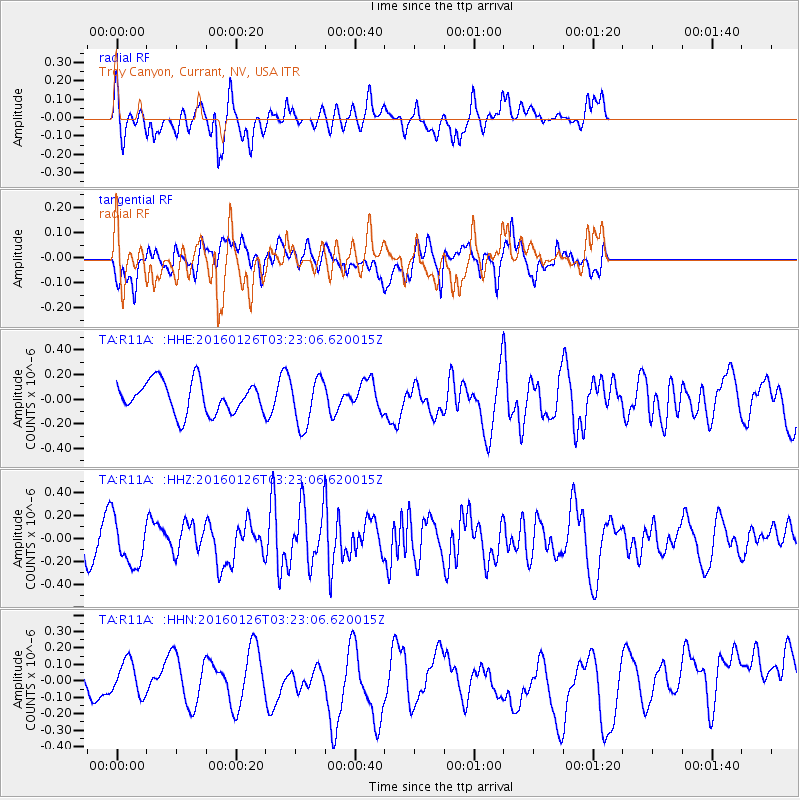
R11A Troy Canyon, Currant, NV, USA - Earthquake Result Viewer
*The percent match for this event was below the threshold and hence no stack was calculated.
| Earthquake location: |
New Ireland Region, P.N.G. |
| Earthquake latitude/longitude: |
-5.3/153.2 |
| Earthquake time(UTC): |
2016/01/26 (026) 03:10:23 GMT |
| Earthquake Depth: |
44 km |
| Earthquake Magnitude: |
5.8 MWP |
| Earthquake Catalog/Contributor: |
NEIC PDE/NEIC COMCAT |
|
| Network: |
TA USArray Transportable Network (new EarthScope stations) |
| Station: |
R11A Troy Canyon, Currant, NV, USA |
| Lat/Lon: |
38.35 N/115.59 W |
| Elevation: |
1756 m |
|
| Distance: |
94.2 deg |
| Az: |
52.022 deg |
| Baz: |
266.598 deg |
| Ray Param: |
$rayparam |
*The percent match for this event was below the threshold and hence was not used in the summary stack. |
|
| Radial Match: |
61.687088 % |
| Radial Bump: |
400 |
| Transverse Match: |
42.355145 % |
| Transverse Bump: |
400 |
| SOD ConfigId: |
7422571 |
| Insert Time: |
2019-04-21 20:14:48.448 +0000 |
| GWidth: |
2.5 |
| Max Bumps: |
400 |
| Tol: |
0.001 |
|
Signal To Noise
| Channel | StoN | STA | LTA |
| TA:R11A: :HHZ:20160126T03:23:06.620015Z | 0.89734524 | 2.0201621E-7 | 2.2512653E-7 |
| TA:R11A: :HHN:20160126T03:23:06.620015Z | 0.87969005 | 1.05497165E-7 | 1.1992537E-7 |
| TA:R11A: :HHE:20160126T03:23:06.620015Z | 1.5238719 | 1.9419886E-7 | 1.2743779E-7 |
| Arrivals |
| Ps | |
| PpPs | |
| PsPs/PpSs | |


