You are here: Home > Network List > US - United States National Seismic Network Stations List
> Station ERPA Erie, Pennsylvania, USA > Earthquake Result Viewer
ERPA Erie, Pennsylvania, USA - Earthquake Result Viewer

| Earthquake location: |
Kuril Islands |
| Earthquake latitude/longitude: |
44.0/147.9 |
| Earthquake time(UTC): |
2015/07/07 (188) 05:10:27 GMT |
| Earthquake Depth: |
38 km |
| Earthquake Magnitude: |
6.3 MO |
| Earthquake Catalog/Contributor: |
NEIC PDE/NEIC ALERT |
|
| Network: |
US United States National Seismic Network |
| Station: |
ERPA Erie, Pennsylvania, USA |
| Lat/Lon: |
42.12 N/79.99 W |
| Elevation: |
306 m |
|
| Distance: |
84.1 deg |
| Az: |
33.723 deg |
| Baz: |
327.409 deg |
| Ray Param: |
0.045655794 |
| Estimated Moho Depth: |
24.0 km |
| Estimated Crust Vp/Vs: |
1.66 |
| Assumed Crust Vp: |
6.419 km/s |
| Estimated Crust Vs: |
3.855 km/s |
| Estimated Crust Poisson's Ratio: |
0.22 |
|
| Radial Match: |
95.3762 % |
| Radial Bump: |
274 |
| Transverse Match: |
78.98367 % |
| Transverse Bump: |
400 |
| SOD ConfigId: |
976571 |
| Insert Time: |
2015-07-21 05:39:05.089 +0000 |
| GWidth: |
2.5 |
| Max Bumps: |
400 |
| Tol: |
0.001 |
|
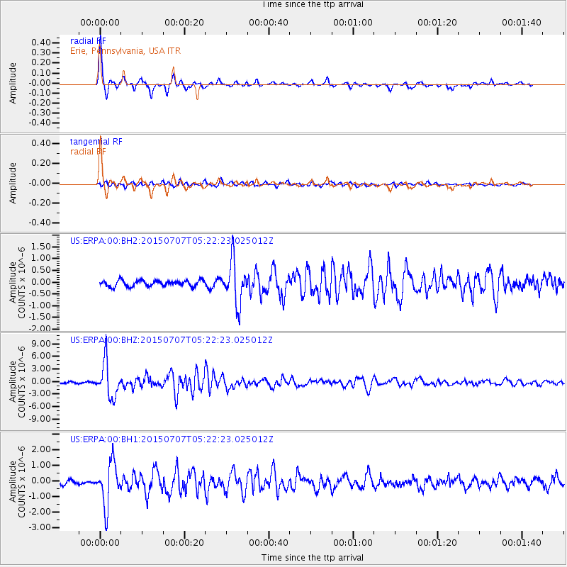
Signal To Noise
| Channel | StoN | STA | LTA |
| US:ERPA:00:BHZ:20150707T05:22:23.025012Z | 27.918514 | 4.2431325E-6 | 1.5198275E-7 |
| US:ERPA:00:BH1:20150707T05:22:23.025012Z | 9.479379 | 1.3863214E-6 | 1.4624601E-7 |
| US:ERPA:00:BH2:20150707T05:22:23.025012Z | 7.206583 | 9.1519644E-7 | 1.2699451E-7 |
| Arrivals |
| Ps | 2.6 SECOND |
| PpPs | 9.7 SECOND |
| PsPs/PpSs | 12 SECOND |


