You are here: Home > Network List > YT07 - POLENET Stations List
> Station P061 P061 > Earthquake Result Viewer
P061 P061 - Earthquake Result Viewer
| Earthquake location: |
New Ireland Region, P.N.G. |
| Earthquake latitude/longitude: |
-5.3/153.2 |
| Earthquake time(UTC): |
2016/01/26 (026) 03:10:23 GMT |
| Earthquake Depth: |
44 km |
| Earthquake Magnitude: |
5.8 MWP |
| Earthquake Catalog/Contributor: |
NEIC PDE/NEIC COMCAT |
|
| Network: |
YT POLENET |
| Station: |
P061 P061 |
| Lat/Lon: |
84.50 S/77.22 E |
| Elevation: |
1758 m |
|
| Distance: |
83.4 deg |
| Az: |
185.407 deg |
| Baz: |
76.505 deg |
| Ray Param: |
0.04615449 |
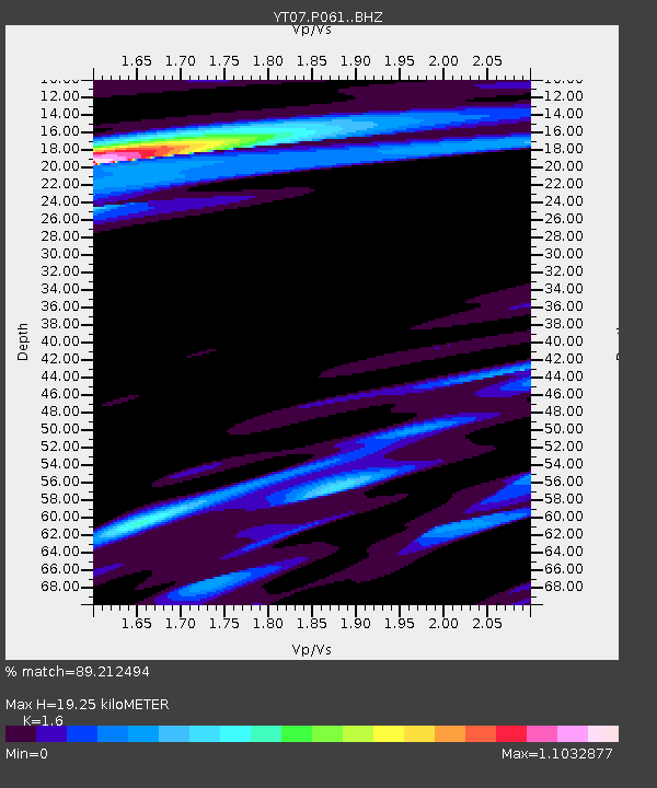
| Estimated Moho Depth: |
19.25 km |
| Estimated Crust Vp/Vs: |
1.60 |
| Assumed Crust Vp: |
6.261 km/s |
| Estimated Crust Vs: |
3.913 km/s |
| Estimated Crust Poisson's Ratio: |
0.18 |
|
| Radial Match: |
89.212494 % |
| Radial Bump: |
400 |
| Transverse Match: |
83.92437 % |
| Transverse Bump: |
400 |
| SOD ConfigId: |
7422571 |
| Insert Time: |
2019-04-21 20:16:54.873 +0000 |
| GWidth: |
2.5 |
| Max Bumps: |
400 |
| Tol: |
0.001 |
|

Signal To Noise
| Channel | StoN | STA | LTA |
| YT:P061: :BHZ:20160126T03:22:14.925007Z | 21.837473 | 4.211544E-6 | 1.9285856E-7 |
| YT:P061: :BHN:20160126T03:22:14.925007Z | 0.89060926 | 1.7737815E-7 | 1.9916496E-7 |
| YT:P061: :BHE:20160126T03:22:14.925007Z | 5.5097413 | 9.106047E-7 | 1.6527177E-7 |
| Arrivals |
| Ps | 1.9 SECOND |
| PpPs | 7.8 SECOND |
| PsPs/PpSs | 9.7 SECOND |


