You are here: Home > Network List > US - United States National Seismic Network Stations List
> Station DGMT Dagmar, Montana, USA > Earthquake Result Viewer
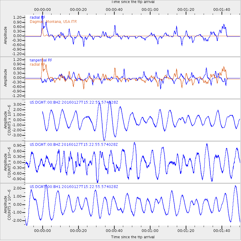
DGMT Dagmar, Montana, USA - Earthquake Result Viewer
*The percent match for this event was below the threshold and hence no stack was calculated.
| Earthquake location: |
Central Mid-Atlantic Ridge |
| Earthquake latitude/longitude: |
1.0/-28.1 |
| Earthquake time(UTC): |
2016/01/27 (027) 15:11:17 GMT |
| Earthquake Depth: |
10 km |
| Earthquake Magnitude: |
5.7 mwc |
| Earthquake Catalog/Contributor: |
NEIC PDE/us |
|
| Network: |
US United States National Seismic Network |
| Station: |
DGMT Dagmar, Montana, USA |
| Lat/Lon: |
48.47 N/104.20 W |
| Elevation: |
0.0 m |
|
| Distance: |
80.0 deg |
| Az: |
319.015 deg |
| Baz: |
99.821 deg |
| Ray Param: |
$rayparam |
*The percent match for this event was below the threshold and hence was not used in the summary stack. |
|
| Radial Match: |
42.30504 % |
| Radial Bump: |
400 |
| Transverse Match: |
38.71487 % |
| Transverse Bump: |
341 |
| SOD ConfigId: |
7422571 |
| Insert Time: |
2019-04-21 20:30:09.855 +0000 |
| GWidth: |
2.5 |
| Max Bumps: |
400 |
| Tol: |
0.001 |
|
Signal To Noise
| Channel | StoN | STA | LTA |
| US:DGMT:00:BHZ:20160127T15:22:55.574028Z | 0.6222159 | 1.728096E-7 | 2.7773254E-7 |
| US:DGMT:00:BH1:20160127T15:22:55.574028Z | 1.1852728 | 1.5469435E-6 | 1.3051371E-6 |
| US:DGMT:00:BH2:20160127T15:22:55.574028Z | 2.0101554 | 2.4775927E-6 | 1.2325379E-6 |
| Arrivals |
| Ps | |
| PpPs | |
| PsPs/PpSs | |


