You are here: Home > Network List > US - United States National Seismic Network Stations List
> Station ERPA Erie, Pennsylvania, USA > Earthquake Result Viewer
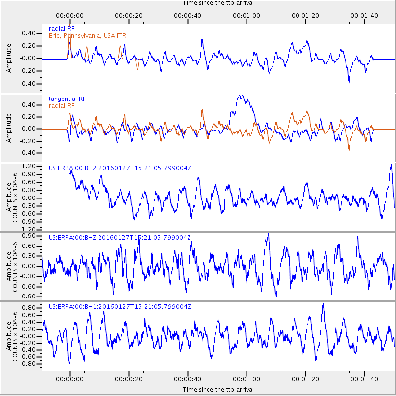
ERPA Erie, Pennsylvania, USA - Earthquake Result Viewer
*The percent match for this event was below the threshold and hence no stack was calculated.
| Earthquake location: |
Central Mid-Atlantic Ridge |
| Earthquake latitude/longitude: |
1.0/-28.1 |
| Earthquake time(UTC): |
2016/01/27 (027) 15:11:17 GMT |
| Earthquake Depth: |
10 km |
| Earthquake Magnitude: |
5.7 mwc |
| Earthquake Catalog/Contributor: |
NEIC PDE/us |
|
| Network: |
US United States National Seismic Network |
| Station: |
ERPA Erie, Pennsylvania, USA |
| Lat/Lon: |
42.12 N/79.99 W |
| Elevation: |
306 m |
|
| Distance: |
61.9 deg |
| Az: |
318.438 deg |
| Baz: |
116.93 deg |
| Ray Param: |
$rayparam |
*The percent match for this event was below the threshold and hence was not used in the summary stack. |
|
| Radial Match: |
49.202747 % |
| Radial Bump: |
400 |
| Transverse Match: |
37.928215 % |
| Transverse Bump: |
400 |
| SOD ConfigId: |
7422571 |
| Insert Time: |
2019-04-21 20:30:11.176 +0000 |
| GWidth: |
2.5 |
| Max Bumps: |
400 |
| Tol: |
0.001 |
|
Signal To Noise
| Channel | StoN | STA | LTA |
| US:ERPA:00:BHZ:20160127T15:21:05.799004Z | 0.6564921 | 1.7464708E-7 | 2.6603075E-7 |
| US:ERPA:00:BH1:20160127T15:21:05.799004Z | 1.2916874 | 4.7520467E-7 | 3.678945E-7 |
| US:ERPA:00:BH2:20160127T15:21:05.799004Z | 0.7296364 | 2.9809485E-7 | 4.0855264E-7 |
| Arrivals |
| Ps | |
| PpPs | |
| PsPs/PpSs | |


