You are here: Home > Network List > WY - Yellowstone Wyoming Seismic Network Stations List
> Station YUF Upper Falls, WY, USA > Earthquake Result Viewer
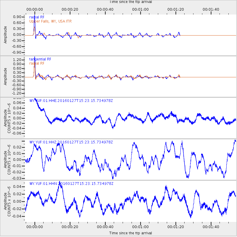
YUF Upper Falls, WY, USA - Earthquake Result Viewer
*The percent match for this event was below the threshold and hence no stack was calculated.
| Earthquake location: |
Central Mid-Atlantic Ridge |
| Earthquake latitude/longitude: |
1.0/-28.1 |
| Earthquake time(UTC): |
2016/01/27 (027) 15:11:17 GMT |
| Earthquake Depth: |
10 km |
| Earthquake Magnitude: |
5.7 mwc |
| Earthquake Catalog/Contributor: |
NEIC PDE/us |
|
| Network: |
WY Yellowstone Wyoming Seismic Network |
| Station: |
YUF Upper Falls, WY, USA |
| Lat/Lon: |
44.71 N/110.51 W |
| Elevation: |
2394 m |
|
| Distance: |
83.8 deg |
| Az: |
314.701 deg |
| Baz: |
94.635 deg |
| Ray Param: |
$rayparam |
*The percent match for this event was below the threshold and hence was not used in the summary stack. |
|
| Radial Match: |
88.520706 % |
| Radial Bump: |
328 |
| Transverse Match: |
90.04986 % |
| Transverse Bump: |
312 |
| SOD ConfigId: |
7422571 |
| Insert Time: |
2019-04-21 20:30:57.441 +0000 |
| GWidth: |
2.5 |
| Max Bumps: |
400 |
| Tol: |
0.001 |
|
Signal To Noise
| Channel | StoN | STA | LTA |
| WY:YUF:01:HHZ:20160127T15:23:15.734978Z | 0.8990142 | 3.1691346E-8 | 3.525122E-8 |
| WY:YUF:01:HHN:20160127T15:23:15.734978Z | 0.86267203 | 3.4585362E-8 | 4.0090974E-8 |
| WY:YUF:01:HHE:20160127T15:23:15.734978Z | 0.926359 | 2.2377222E-8 | 2.4156101E-8 |
| Arrivals |
| Ps | |
| PpPs | |
| PsPs/PpSs | |


