You are here: Home > Network List > 6E - Wabash Valley Seismic Zone Stations List
> Station WB45 KY, USA > Earthquake Result Viewer
WB45 KY, USA - Earthquake Result Viewer
| Earthquake location: |
Kamchatka Peninsula, Russia |
| Earthquake latitude/longitude: |
54.0/158.5 |
| Earthquake time(UTC): |
2016/01/30 (030) 03:25:10 GMT |
| Earthquake Depth: |
161 km |
| Earthquake Magnitude: |
7.2 MWW, 7.0 MI, 7.2 MWB |
| Earthquake Catalog/Contributor: |
NEIC PDE/NEIC COMCAT |
|
| Network: |
6E Wabash Valley Seismic Zone |
| Station: |
WB45 KY, USA |
| Lat/Lon: |
37.72 N/86.52 W |
| Elevation: |
176 m |
|
| Distance: |
72.9 deg |
| Az: |
48.775 deg |
| Baz: |
325.953 deg |
| Ray Param: |
0.052947566 |
| Estimated Moho Depth: |
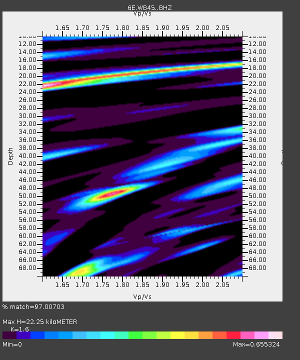
22.25 km |
| Estimated Crust Vp/Vs: |
1.60 |
| Assumed Crust Vp: |
6.444 km/s |
| Estimated Crust Vs: |
4.027 km/s |
| Estimated Crust Poisson's Ratio: |
0.18 |
|
| Radial Match: |
97.00703 % |
| Radial Bump: |
383 |
| Transverse Match: |
86.55216 % |
| Transverse Bump: |
400 |
| SOD ConfigId: |
7422571 |
| Insert Time: |
2019-04-21 20:32:33.552 +0000 |
| GWidth: |
2.5 |
| Max Bumps: |
400 |
| Tol: |
0.001 |
|

Signal To Noise
| Channel | StoN | STA | LTA |
| 6E:WB45: :BHZ:20160130T03:35:50.959978Z | 25.269075 | 1.4019687E-5 | 5.54816E-7 |
| 6E:WB45: :BHN:20160130T03:35:50.959978Z | 10.346995 | 4.539479E-6 | 4.3872436E-7 |
| 6E:WB45: :BHE:20160130T03:35:50.959978Z | 12.662052 | 3.7063987E-6 | 2.9271706E-7 |
| Arrivals |
| Ps | 2.2 SECOND |
| PpPs | 8.6 SECOND |
| PsPs/PpSs | 11 SECOND |


