You are here: Home > Network List > 7A - Mid-Atlantic Geophysical Integrative Collaboration Stations List
> Station PAUL Paulding, Ohio USA > Earthquake Result Viewer
PAUL Paulding, Ohio USA - Earthquake Result Viewer
| Earthquake location: |
Kamchatka Peninsula, Russia |
| Earthquake latitude/longitude: |
54.0/158.5 |
| Earthquake time(UTC): |
2016/01/30 (030) 03:25:10 GMT |
| Earthquake Depth: |
161 km |
| Earthquake Magnitude: |
7.2 MWW, 7.0 MI, 7.2 MWB |
| Earthquake Catalog/Contributor: |
NEIC PDE/NEIC COMCAT |
|
| Network: |
7A Mid-Atlantic Geophysical Integrative Collaboration |
| Station: |
PAUL Paulding, Ohio USA |
| Lat/Lon: |
41.14 N/84.55 W |
| Elevation: |
0.0 m |
|
| Distance: |
70.9 deg |
| Az: |
45.438 deg |
| Baz: |
326.166 deg |
| Ray Param: |
0.054241464 |
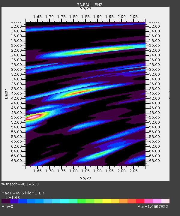
| Estimated Moho Depth: |
49.5 km |
| Estimated Crust Vp/Vs: |
1.63 |
| Assumed Crust Vp: |
6.498 km/s |
| Estimated Crust Vs: |
3.986 km/s |
| Estimated Crust Poisson's Ratio: |
0.20 |
|
| Radial Match: |
96.14633 % |
| Radial Bump: |
306 |
| Transverse Match: |
85.40064 % |
| Transverse Bump: |
400 |
| SOD ConfigId: |
7422571 |
| Insert Time: |
2019-04-21 20:32:44.973 +0000 |
| GWidth: |
2.5 |
| Max Bumps: |
400 |
| Tol: |
0.001 |
|

Signal To Noise
| Channel | StoN | STA | LTA |
| 7A:PAUL: :BHZ:20160130T03:35:39.240007Z | 33.649418 | 1.6188367E-5 | 4.810891E-7 |
| 7A:PAUL: :BHN:20160130T03:35:39.240007Z | 11.946142 | 6.868783E-6 | 5.749792E-7 |
| 7A:PAUL: :BHE:20160130T03:35:39.240007Z | 12.96327 | 4.670623E-6 | 3.6029667E-7 |
| Arrivals |
| Ps | 5.0 SECOND |
| PpPs | 19 SECOND |
| PsPs/PpSs | 24 SECOND |


