You are here: Home > Network List > 7A - Mid-Atlantic Geophysical Integrative Collaboration Stations List
> Station PVGR Lower Salem, Ohio USA > Earthquake Result Viewer
PVGR Lower Salem, Ohio USA - Earthquake Result Viewer
| Earthquake location: |
Kamchatka Peninsula, Russia |
| Earthquake latitude/longitude: |
54.0/158.5 |
| Earthquake time(UTC): |
2016/01/30 (030) 03:25:10 GMT |
| Earthquake Depth: |
161 km |
| Earthquake Magnitude: |
7.2 MWW, 7.0 MI, 7.2 MWB |
| Earthquake Catalog/Contributor: |
NEIC PDE/NEIC COMCAT |
|
| Network: |
7A Mid-Atlantic Geophysical Integrative Collaboration |
| Station: |
PVGR Lower Salem, Ohio USA |
| Lat/Lon: |
39.57 N/81.38 W |
| Elevation: |
0.0 m |
|
| Distance: |
73.5 deg |
| Az: |
44.201 deg |
| Baz: |
327.831 deg |
| Ray Param: |
0.052513294 |
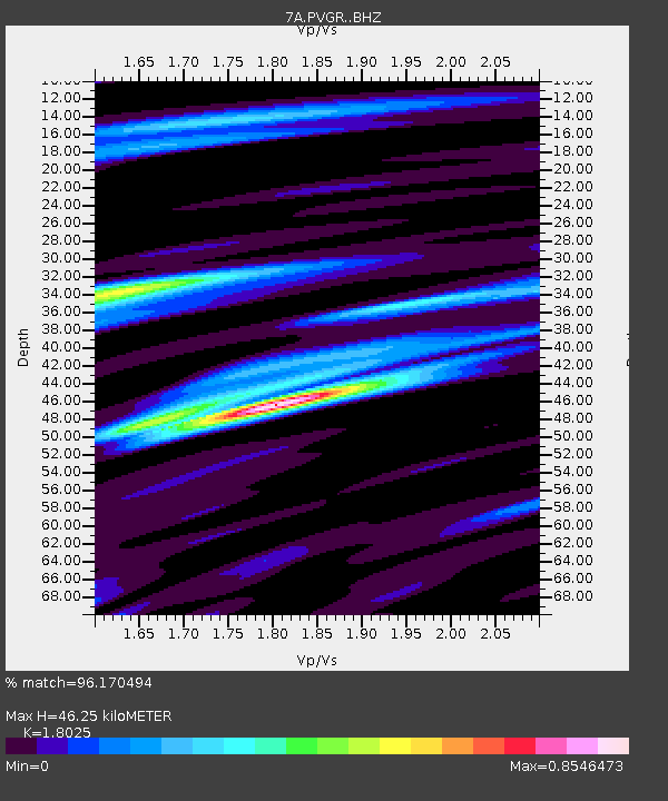
| Estimated Moho Depth: |
46.25 km |
| Estimated Crust Vp/Vs: |
1.80 |
| Assumed Crust Vp: |
6.207 km/s |
| Estimated Crust Vs: |
3.444 km/s |
| Estimated Crust Poisson's Ratio: |
0.28 |
|
| Radial Match: |
96.170494 % |
| Radial Bump: |
375 |
| Transverse Match: |
73.68303 % |
| Transverse Bump: |
400 |
| SOD ConfigId: |
7422571 |
| Insert Time: |
2019-04-21 20:32:45.307 +0000 |
| GWidth: |
2.5 |
| Max Bumps: |
400 |
| Tol: |
0.001 |
|

Signal To Noise
| Channel | StoN | STA | LTA |
| 7A:PVGR: :BHZ:20160130T03:35:54.78499Z | 29.62742 | 1.6940865E-5 | 5.717968E-7 |
| 7A:PVGR: :BHN:20160130T03:35:54.78499Z | 9.84643 | 6.4861615E-6 | 6.5873235E-7 |
| 7A:PVGR: :BHE:20160130T03:35:54.78499Z | 8.361094 | 3.6748231E-6 | 4.3951462E-7 |
| Arrivals |
| Ps | 6.2 SECOND |
| PpPs | 20 SECOND |
| PsPs/PpSs | 26 SECOND |


