You are here: Home > Network List > UU - University of Utah Regional Network Stations List
> Station KNB Kanab, UT, USA > Earthquake Result Viewer
KNB Kanab, UT, USA - Earthquake Result Viewer
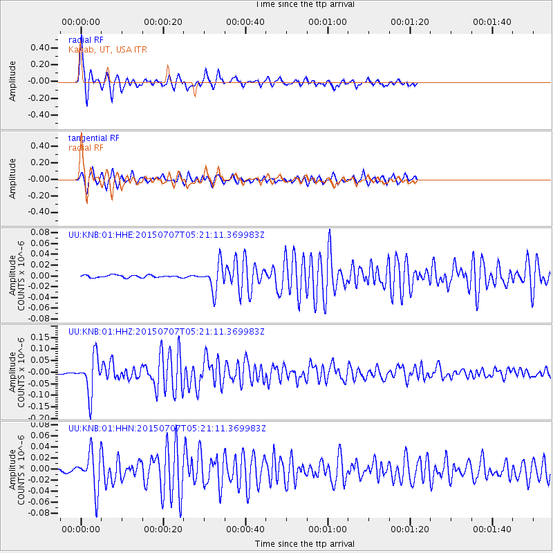
| Earthquake location: |
Kuril Islands |
| Earthquake latitude/longitude: |
44.0/147.9 |
| Earthquake time(UTC): |
2015/07/07 (188) 05:10:27 GMT |
| Earthquake Depth: |
38 km |
| Earthquake Magnitude: |
6.3 MO |
| Earthquake Catalog/Contributor: |
NEIC PDE/NEIC ALERT |
|
| Network: |
UU University of Utah Regional Network |
| Station: |
KNB Kanab, UT, USA |
| Lat/Lon: |
37.02 N/112.82 W |
| Elevation: |
1715 m |
|
| Distance: |
71.2 deg |
| Az: |
56.561 deg |
| Baz: |
311.186 deg |
| Ray Param: |
0.05441621 |
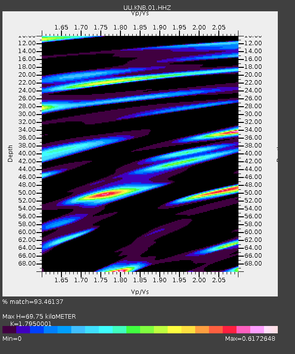
| Estimated Moho Depth: |
69.75 km |
| Estimated Crust Vp/Vs: |
1.80 |
| Assumed Crust Vp: |
6.194 km/s |
| Estimated Crust Vs: |
3.451 km/s |
| Estimated Crust Poisson's Ratio: |
0.27 |
|
| Radial Match: |
93.46137 % |
| Radial Bump: |
371 |
| Transverse Match: |
91.06185 % |
| Transverse Bump: |
351 |
| SOD ConfigId: |
976571 |
| Insert Time: |
2015-07-21 05:41:36.114 +0000 |
| GWidth: |
2.5 |
| Max Bumps: |
400 |
| Tol: |
0.001 |
|
Signal To Noise
| Channel | StoN | STA | LTA |
| UU:KNB:01:HHZ:20150707T05:21:11.369983Z | 43.149063 | 8.3236266E-8 | 1.9290398E-9 |
| UU:KNB:01:HHN:20150707T05:21:11.369983Z | 16.591888 | 3.48388E-8 | 2.0997488E-9 |
| UU:KNB:01:HHE:20150707T05:21:11.369983Z | 11.305256 | 2.5268136E-8 | 2.2350788E-9 |
| Arrivals |
| Ps | 9.3 SECOND |
| PpPs | 30 SECOND |
| PsPs/PpSs | 40 SECOND |


