You are here: Home > Network List > UU - University of Utah Regional Network Stations List
> Station MTPU Mt. Pierson, UT, USA > Earthquake Result Viewer
MTPU Mt. Pierson, UT, USA - Earthquake Result Viewer
| Earthquake location: |
Kuril Islands |
| Earthquake latitude/longitude: |
44.0/147.9 |
| Earthquake time(UTC): |
2015/07/07 (188) 05:10:27 GMT |
| Earthquake Depth: |
38 km |
| Earthquake Magnitude: |
6.3 MO |
| Earthquake Catalog/Contributor: |
NEIC PDE/NEIC ALERT |
|
| Network: |
UU University of Utah Regional Network |
| Station: |
MTPU Mt. Pierson, UT, USA |
| Lat/Lon: |
38.04 N/112.18 W |
| Elevation: |
3112 m |
|
| Distance: |
70.9 deg |
| Az: |
55.394 deg |
| Baz: |
311.195 deg |
| Ray Param: |
0.054600656 |
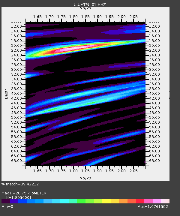
| Estimated Moho Depth: |
20.75 km |
| Estimated Crust Vp/Vs: |
1.81 |
| Assumed Crust Vp: |
6.276 km/s |
| Estimated Crust Vs: |
3.477 km/s |
| Estimated Crust Poisson's Ratio: |
0.28 |
|
| Radial Match: |
89.42212 % |
| Radial Bump: |
400 |
| Transverse Match: |
80.65405 % |
| Transverse Bump: |
400 |
| SOD ConfigId: |
976571 |
| Insert Time: |
2015-07-21 05:41:48.639 +0000 |
| GWidth: |
2.5 |
| Max Bumps: |
400 |
| Tol: |
0.001 |
|

Signal To Noise
| Channel | StoN | STA | LTA |
| UU:MTPU:01:HHZ:20150707T05:21:09.60802Z | 20.23499 | 7.1713636E-8 | 3.544041E-9 |
| UU:MTPU:01:HHN:20150707T05:21:09.60802Z | 5.648268 | 1.7573683E-8 | 3.11134E-9 |
| UU:MTPU:01:HHE:20150707T05:21:09.60802Z | 7.133305 | 2.169901E-8 | 3.0419294E-9 |
| Arrivals |
| Ps | 2.8 SECOND |
| PpPs | 9.0 SECOND |
| PsPs/PpSs | 12 SECOND |


