You are here: Home > Network List > UU - University of Utah Regional Network Stations List
> Station RDMU Red Mountain, UT, USA > Earthquake Result Viewer
RDMU Red Mountain, UT, USA - Earthquake Result Viewer
| Earthquake location: |
Kuril Islands |
| Earthquake latitude/longitude: |
44.0/147.9 |
| Earthquake time(UTC): |
2015/07/07 (188) 05:10:27 GMT |
| Earthquake Depth: |
38 km |
| Earthquake Magnitude: |
6.3 MO |
| Earthquake Catalog/Contributor: |
NEIC PDE/NEIC ALERT |
|
| Network: |
UU University of Utah Regional Network |
| Station: |
RDMU Red Mountain, UT, USA |
| Lat/Lon: |
40.57 N/109.57 W |
| Elevation: |
2087 m |
|
| Distance: |
70.8 deg |
| Az: |
51.969 deg |
| Baz: |
311.721 deg |
| Ray Param: |
0.054701008 |
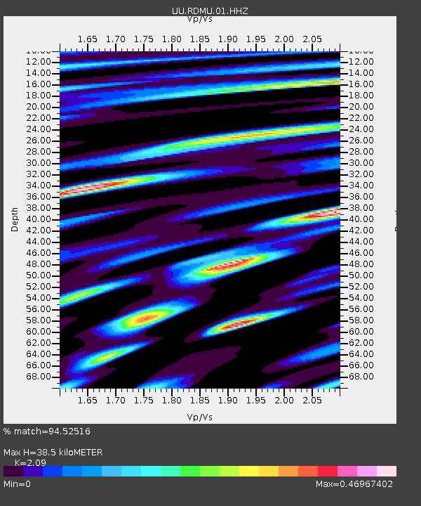
| Estimated Moho Depth: |
38.5 km |
| Estimated Crust Vp/Vs: |
2.09 |
| Assumed Crust Vp: |
6.207 km/s |
| Estimated Crust Vs: |
2.97 km/s |
| Estimated Crust Poisson's Ratio: |
0.35 |
|
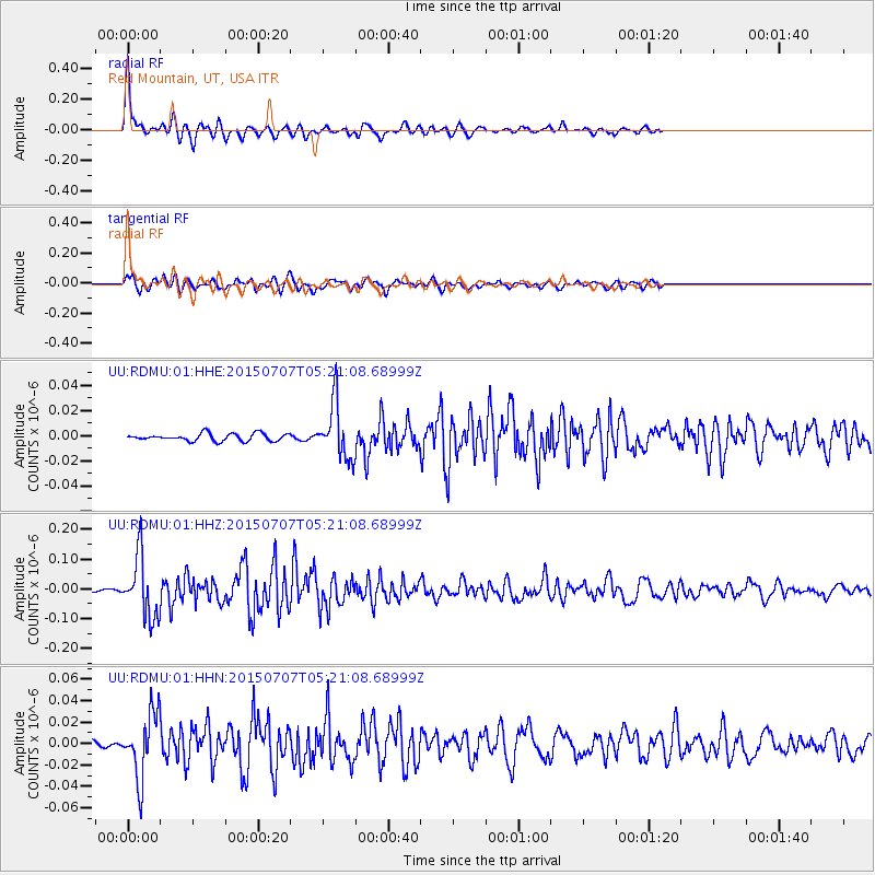
| Radial Match: |
94.52516 % |
| Radial Bump: |
332 |
| Transverse Match: |
86.4118 % |
| Transverse Bump: |
369 |
| SOD ConfigId: |
976571 |
| Insert Time: |
2015-07-21 05:42:05.326 +0000 |
| GWidth: |
2.5 |
| Max Bumps: |
400 |
| Tol: |
0.001 |
|
Signal To Noise
| Channel | StoN | STA | LTA |
| UU:RDMU:01:HHZ:20150707T05:21:08.68999Z | 35.20729 | 1.026592E-7 | 2.9158507E-9 |
| UU:RDMU:01:HHN:20150707T05:21:08.68999Z | 12.897479 | 2.9824502E-8 | 2.3124287E-9 |
| UU:RDMU:01:HHE:20150707T05:21:08.68999Z | 7.597862 | 2.2057097E-8 | 2.9030665E-9 |
| Arrivals |
| Ps | 7.0 SECOND |
| PpPs | 19 SECOND |
| PsPs/PpSs | 26 SECOND |


