You are here: Home > Network List > BE - Belgian Seismic Network Stations List
> Station RCHB Rochefort, Belgium > Earthquake Result Viewer
RCHB Rochefort, Belgium - Earthquake Result Viewer
| Earthquake location: |
Kamchatka Peninsula, Russia |
| Earthquake latitude/longitude: |
54.0/158.5 |
| Earthquake time(UTC): |
2016/01/30 (030) 03:25:10 GMT |
| Earthquake Depth: |
161 km |
| Earthquake Magnitude: |
7.2 MWW, 7.0 MI, 7.2 MWB |
| Earthquake Catalog/Contributor: |
NEIC PDE/NEIC COMCAT |
|
| Network: |
BE Belgian Seismic Network |
| Station: |
RCHB Rochefort, Belgium |
| Lat/Lon: |
50.16 N/5.23 E |
| Elevation: |
191 m |
|
| Distance: |
73.8 deg |
| Az: |
342.471 deg |
| Baz: |
16.045 deg |
| Ray Param: |
0.052339848 |
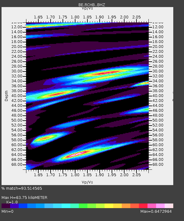
| Estimated Moho Depth: |
63.75 km |
| Estimated Crust Vp/Vs: |
1.80 |
| Assumed Crust Vp: |
6.276 km/s |
| Estimated Crust Vs: |
3.487 km/s |
| Estimated Crust Poisson's Ratio: |
0.28 |
|
| Radial Match: |
93.514565 % |
| Radial Bump: |
400 |
| Transverse Match: |
78.6077 % |
| Transverse Bump: |
400 |
| SOD ConfigId: |
7422571 |
| Insert Time: |
2019-04-21 20:34:17.437 +0000 |
| GWidth: |
2.5 |
| Max Bumps: |
400 |
| Tol: |
0.001 |
|

Signal To Noise
| Channel | StoN | STA | LTA |
| BE:RCHB: :BHZ:20160130T03:35:56.318987Z | 16.07478 | 1.5387839E-5 | 9.572659E-7 |
| BE:RCHB: :BHN:20160130T03:35:56.318987Z | 9.906192 | 6.1024302E-6 | 6.160218E-7 |
| BE:RCHB: :BHE:20160130T03:35:56.318987Z | 2.5641098 | 1.5633665E-6 | 6.097112E-7 |
| Arrivals |
| Ps | 8.4 SECOND |
| PpPs | 28 SECOND |
| PsPs/PpSs | 36 SECOND |


