You are here: Home > Network List > CN - Canadian National Seismograph Network Stations List
> Station KITB Kitimat, BC, CA > Earthquake Result Viewer
KITB Kitimat, BC, CA - Earthquake Result Viewer
| Earthquake location: |
Kamchatka Peninsula, Russia |
| Earthquake latitude/longitude: |
54.0/158.5 |
| Earthquake time(UTC): |
2016/01/30 (030) 03:25:10 GMT |
| Earthquake Depth: |
161 km |
| Earthquake Magnitude: |
7.2 MWW, 7.0 MI, 7.2 MWB |
| Earthquake Catalog/Contributor: |
NEIC PDE/NEIC COMCAT |
|
| Network: |
CN Canadian National Seismograph Network |
| Station: |
KITB Kitimat, BC, CA |
| Lat/Lon: |
54.08 N/128.64 W |
| Elevation: |
72 m |
|
| Distance: |
41.0 deg |
| Az: |
59.123 deg |
| Baz: |
300.714 deg |
| Ray Param: |
0.0734442 |
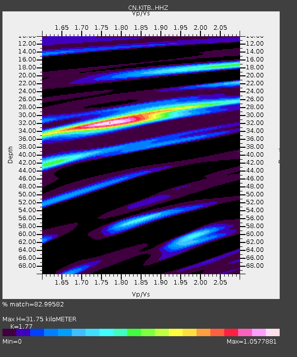
| Estimated Moho Depth: |
31.75 km |
| Estimated Crust Vp/Vs: |
1.77 |
| Assumed Crust Vp: |
6.438 km/s |
| Estimated Crust Vs: |
3.637 km/s |
| Estimated Crust Poisson's Ratio: |
0.27 |
|
| Radial Match: |
82.99582 % |
| Radial Bump: |
400 |
| Transverse Match: |
70.103424 % |
| Transverse Bump: |
400 |
| SOD ConfigId: |
7422571 |
| Insert Time: |
2019-04-21 20:36:11.590 +0000 |
| GWidth: |
2.5 |
| Max Bumps: |
400 |
| Tol: |
0.001 |
|

Signal To Noise
| Channel | StoN | STA | LTA |
| CN:KITB: :HHZ:20160130T03:32:07.259996Z | 7.9605603 | 1.03685215E-5 | 1.3024863E-6 |
| CN:KITB: :HHN:20160130T03:32:07.259996Z | 3.2180657 | 2.6837058E-6 | 8.3394997E-7 |
| CN:KITB: :HHE:20160130T03:32:07.259996Z | 5.356255 | 4.9973464E-6 | 9.3299263E-7 |
| Arrivals |
| Ps | 4.1 SECOND |
| PpPs | 13 SECOND |
| PsPs/PpSs | 17 SECOND |


