You are here: Home > Network List > CI - Caltech Regional Seismic Network Stations List
> Station BAR Barrett, Tecate, CA, USA > Earthquake Result Viewer
BAR Barrett, Tecate, CA, USA - Earthquake Result Viewer
| Earthquake location: |
Volcano Islands, Japan Region |
| Earthquake latitude/longitude: |
22.3/143.7 |
| Earthquake time(UTC): |
2000/03/28 (088) 11:00:22 GMT |
| Earthquake Depth: |
126 km |
| Earthquake Magnitude: |
6.8 MB, 7.6 MS, 7.6 MW, 7.6 MW |
| Earthquake Catalog/Contributor: |
WHDF/NEIC |
|
| Network: |
CI Caltech Regional Seismic Network |
| Station: |
BAR Barrett, Tecate, CA, USA |
| Lat/Lon: |
32.68 N/116.67 W |
| Elevation: |
521 m |
|
| Distance: |
85.8 deg |
| Az: |
56.486 deg |
| Baz: |
293.748 deg |
| Ray Param: |
0.04421584 |
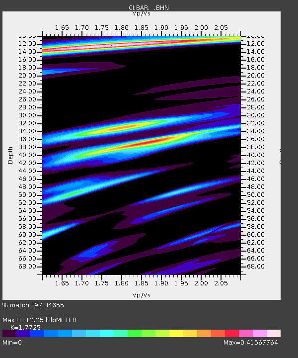
| Estimated Moho Depth: |
12.25 km |
| Estimated Crust Vp/Vs: |
1.77 |
| Assumed Crust Vp: |
6.264 km/s |
| Estimated Crust Vs: |
3.534 km/s |
| Estimated Crust Poisson's Ratio: |
0.27 |
|
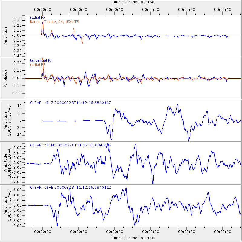
| Radial Match: |
97.34655 % |
| Radial Bump: |
380 |
| Transverse Match: |
94.1886 % |
| Transverse Bump: |
400 |
| SOD ConfigId: |
3753 |
| Insert Time: |
2010-02-26 00:06:05.888 +0000 |
| GWidth: |
2.5 |
| Max Bumps: |
400 |
| Tol: |
0.001 |
|
Signal To Noise
| Channel | StoN | STA | LTA |
| CI:BAR: :BHN:20000328T11:12:16.684011Z | 1.1010803 | 1.8217713E-7 | 1.6545309E-7 |
| CI:BAR: :BHE:20000328T11:12:16.684011Z | 2.6745305 | 2.4447252E-7 | 9.140764E-8 |
| CI:BAR: :BHZ:20000328T11:12:16.684011Z | 3.1509173 | 1.5093857E-6 | 4.790306E-7 |
| Arrivals |
| Ps | 1.5 SECOND |
| PpPs | 5.3 SECOND |
| PsPs/PpSs | 6.8 SECOND |


