You are here: Home > Network List > KN - Kyrgyz Seismic Telemetry Network Stations List
> Station EKS2 KN.EKS2 > Earthquake Result Viewer
EKS2 KN.EKS2 - Earthquake Result Viewer

| Earthquake location: |
Kamchatka Peninsula, Russia |
| Earthquake latitude/longitude: |
54.0/158.5 |
| Earthquake time(UTC): |
2016/01/30 (030) 03:25:10 GMT |
| Earthquake Depth: |
161 km |
| Earthquake Magnitude: |
7.2 MWW, 7.0 MI, 7.2 MWB |
| Earthquake Catalog/Contributor: |
NEIC PDE/NEIC COMCAT |
|
| Network: |
KN Kyrgyz Seismic Telemetry Network |
| Station: |
EKS2 KN.EKS2 |
| Lat/Lon: |
42.66 N/73.78 E |
| Elevation: |
1360 m |
|
| Distance: |
54.2 deg |
| Az: |
295.086 deg |
| Baz: |
46.447 deg |
| Ray Param: |
0.065070085 |
| Estimated Moho Depth: |
10.5 km |
| Estimated Crust Vp/Vs: |
1.73 |
| Assumed Crust Vp: |
6.316 km/s |
| Estimated Crust Vs: |
3.651 km/s |
| Estimated Crust Poisson's Ratio: |
0.25 |
|
| Radial Match: |
93.5826 % |
| Radial Bump: |
367 |
| Transverse Match: |
86.234055 % |
| Transverse Bump: |
400 |
| SOD ConfigId: |
7422571 |
| Insert Time: |
2019-04-21 20:38:32.845 +0000 |
| GWidth: |
2.5 |
| Max Bumps: |
400 |
| Tol: |
0.001 |
|
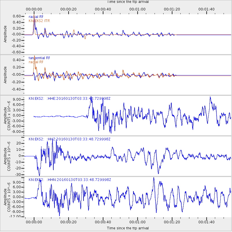
Signal To Noise
| Channel | StoN | STA | LTA |
| KN:EKS2: :HHZ:20160130T03:33:48.729998Z | 51.03008 | 1.4075694E-5 | 2.758313E-7 |
| KN:EKS2: :HHN:20160130T03:33:48.729998Z | 19.148907 | 5.3386034E-6 | 2.7879418E-7 |
| KN:EKS2: :HHE:20160130T03:33:48.729998Z | 25.481457 | 4.836333E-6 | 1.8979814E-7 |
| Arrivals |
| Ps | 1.3 SECOND |
| PpPs | 4.3 SECOND |
| PsPs/PpSs | 5.6 SECOND |


