You are here: Home > Network List > KO - Kandilli Observatory Digital Broadband Seismic Network Stations List
> Station MDUB Mudurnu-Bolu-Turkey > Earthquake Result Viewer
MDUB Mudurnu-Bolu-Turkey - Earthquake Result Viewer
| Earthquake location: |
Kamchatka Peninsula, Russia |
| Earthquake latitude/longitude: |
54.0/158.5 |
| Earthquake time(UTC): |
2016/01/30 (030) 03:25:10 GMT |
| Earthquake Depth: |
161 km |
| Earthquake Magnitude: |
7.2 MWW, 7.0 MI, 7.2 MWB |
| Earthquake Catalog/Contributor: |
NEIC PDE/NEIC COMCAT |
|
| Network: |
KO Kandilli Observatory Digital Broadband Seismic Network |
| Station: |
MDUB Mudurnu-Bolu-Turkey |
| Lat/Lon: |
40.47 N/31.20 E |
| Elevation: |
1109 m |
|
| Distance: |
75.6 deg |
| Az: |
321.207 deg |
| Baz: |
28.996 deg |
| Ray Param: |
0.051159814 |
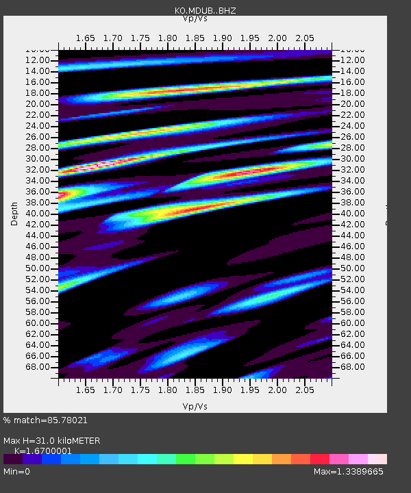
| Estimated Moho Depth: |
31.0 km |
| Estimated Crust Vp/Vs: |
1.67 |
| Assumed Crust Vp: |
6.287 km/s |
| Estimated Crust Vs: |
3.765 km/s |
| Estimated Crust Poisson's Ratio: |
0.22 |
|
| Radial Match: |
85.78021 % |
| Radial Bump: |
400 |
| Transverse Match: |
80.68105 % |
| Transverse Bump: |
400 |
| SOD ConfigId: |
7422571 |
| Insert Time: |
2019-04-21 20:38:43.048 +0000 |
| GWidth: |
2.5 |
| Max Bumps: |
400 |
| Tol: |
0.001 |
|

Signal To Noise
| Channel | StoN | STA | LTA |
| KO:MDUB: :BHZ:20160130T03:36:06.539995Z | 49.49642 | 4.920114E-5 | 9.940343E-7 |
| KO:MDUB: :BHN:20160130T03:36:06.539995Z | 26.467026 | 1.42335575E-5 | 5.3778456E-7 |
| KO:MDUB: :BHE:20160130T03:36:06.539995Z | 26.30949 | 1.0417579E-5 | 3.959628E-7 |
| Arrivals |
| Ps | 3.4 SECOND |
| PpPs | 13 SECOND |
| PsPs/PpSs | 16 SECOND |


