You are here: Home > Network List > KR - Kyrgyz Digital Network Stations List
> Station DRK Karamyk, Kyrgyzstan > Earthquake Result Viewer
DRK Karamyk, Kyrgyzstan - Earthquake Result Viewer
| Earthquake location: |
Kamchatka Peninsula, Russia |
| Earthquake latitude/longitude: |
54.0/158.5 |
| Earthquake time(UTC): |
2016/01/30 (030) 03:25:10 GMT |
| Earthquake Depth: |
161 km |
| Earthquake Magnitude: |
7.2 MWW, 7.0 MI, 7.2 MWB |
| Earthquake Catalog/Contributor: |
NEIC PDE/NEIC COMCAT |
|
| Network: |
KR Kyrgyz Digital Network |
| Station: |
DRK Karamyk, Kyrgyzstan |
| Lat/Lon: |
39.48 N/71.80 E |
| Elevation: |
2627 m |
|
| Distance: |
57.5 deg |
| Az: |
293.621 deg |
| Baz: |
44.33 deg |
| Ray Param: |
0.06294674 |
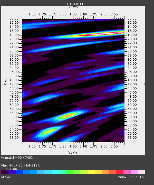
| Estimated Moho Depth: |
17.25 km |
| Estimated Crust Vp/Vs: |
1.99 |
| Assumed Crust Vp: |
6.306 km/s |
| Estimated Crust Vs: |
3.169 km/s |
| Estimated Crust Poisson's Ratio: |
0.33 |
|
| Radial Match: |
92.47481 % |
| Radial Bump: |
400 |
| Transverse Match: |
80.958305 % |
| Transverse Bump: |
400 |
| SOD ConfigId: |
7422571 |
| Insert Time: |
2019-04-21 20:38:49.311 +0000 |
| GWidth: |
2.5 |
| Max Bumps: |
400 |
| Tol: |
0.001 |
|

Signal To Noise
| Channel | StoN | STA | LTA |
| KR:DRK: :BHZ:20160130T03:34:12.099993Z | 81.15487 | 1.2310896E-5 | 1.5169633E-7 |
| KR:DRK: :BHN:20160130T03:34:12.099993Z | 19.369987 | 4.5512934E-6 | 2.3496627E-7 |
| KR:DRK: :BHE:20160130T03:34:12.099993Z | 19.497776 | 4.7528956E-6 | 2.4376604E-7 |
| Arrivals |
| Ps | 2.8 SECOND |
| PpPs | 7.8 SECOND |
| PsPs/PpSs | 11 SECOND |


