You are here: Home > Network List > LD - Lamont-Doherty Cooperative Seismographic Network Stations List
> Station LUPA Lehigh University, PA > Earthquake Result Viewer
LUPA Lehigh University, PA - Earthquake Result Viewer
| Earthquake location: |
Kamchatka Peninsula, Russia |
| Earthquake latitude/longitude: |
54.0/158.5 |
| Earthquake time(UTC): |
2016/01/30 (030) 03:25:10 GMT |
| Earthquake Depth: |
161 km |
| Earthquake Magnitude: |
7.2 MWW, 7.0 MI, 7.2 MWB |
| Earthquake Catalog/Contributor: |
NEIC PDE/NEIC COMCAT |
|
| Network: |
LD Lamont-Doherty Cooperative Seismographic Network |
| Station: |
LUPA Lehigh University, PA |
| Lat/Lon: |
40.60 N/75.37 W |
| Elevation: |
236 m |
|
| Distance: |
75.0 deg |
| Az: |
39.544 deg |
| Baz: |
330.426 deg |
| Ray Param: |
0.051530197 |
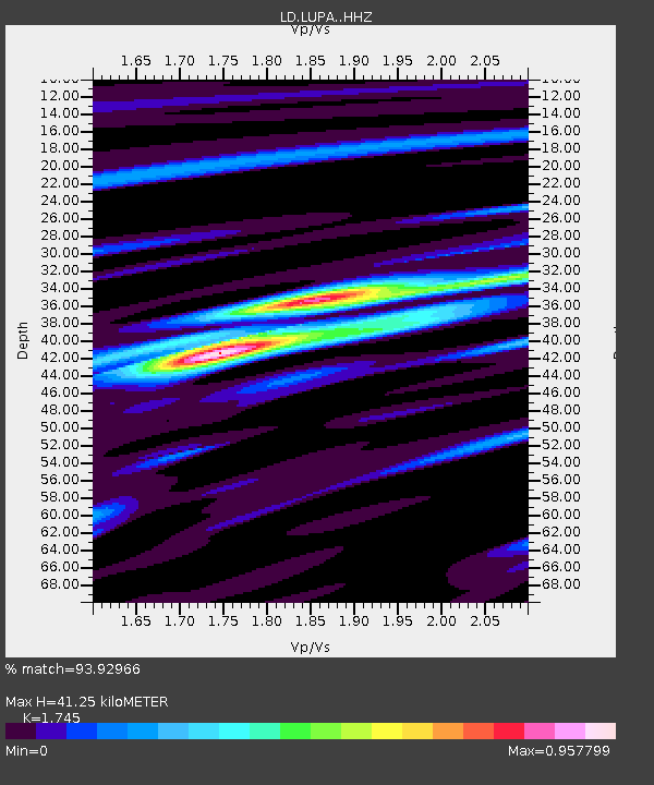
| Estimated Moho Depth: |
41.25 km |
| Estimated Crust Vp/Vs: |
1.75 |
| Assumed Crust Vp: |
6.283 km/s |
| Estimated Crust Vs: |
3.601 km/s |
| Estimated Crust Poisson's Ratio: |
0.26 |
|
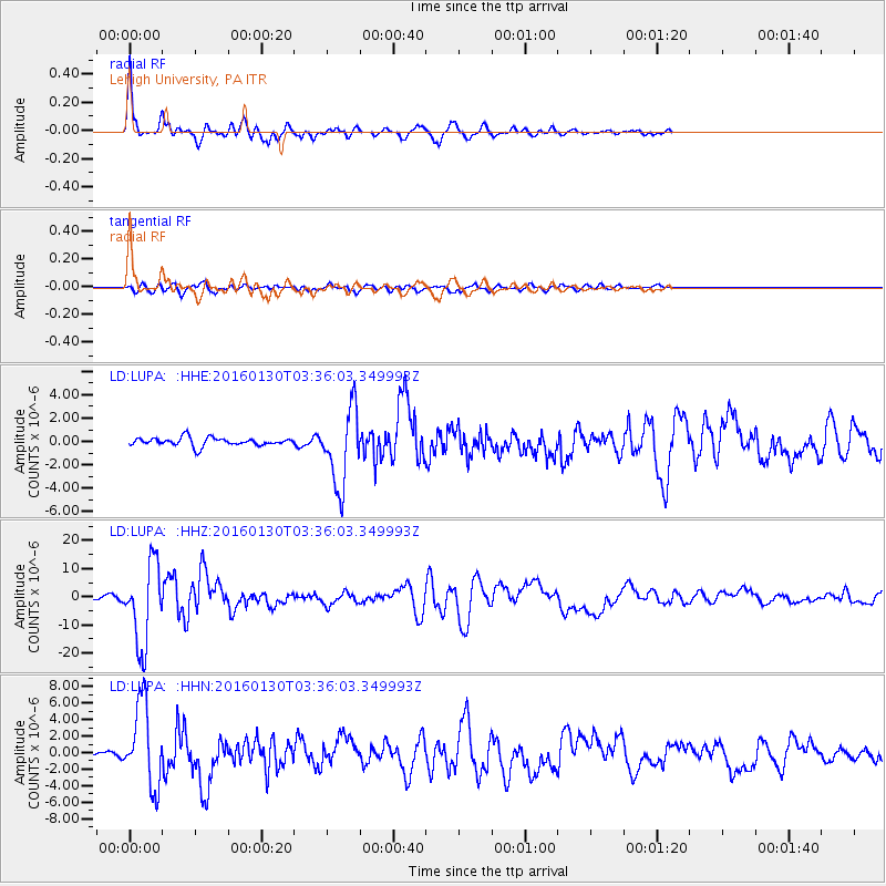
| Radial Match: |
93.92966 % |
| Radial Bump: |
392 |
| Transverse Match: |
73.56713 % |
| Transverse Bump: |
400 |
| SOD ConfigId: |
7422571 |
| Insert Time: |
2019-04-21 20:39:14.402 +0000 |
| GWidth: |
2.5 |
| Max Bumps: |
400 |
| Tol: |
0.001 |
|
Signal To Noise
| Channel | StoN | STA | LTA |
| LD:LUPA: :HHZ:20160130T03:36:03.349993Z | 25.353374 | 1.4381424E-5 | 5.6723906E-7 |
| LD:LUPA: :HHN:20160130T03:36:03.349993Z | 7.7271013 | 4.9880737E-6 | 6.455297E-7 |
| LD:LUPA: :HHE:20160130T03:36:03.349993Z | 9.324518 | 3.269612E-6 | 3.5064676E-7 |
| Arrivals |
| Ps | 5.0 SECOND |
| PpPs | 17 SECOND |
| PsPs/PpSs | 23 SECOND |


