You are here: Home > Network List > MB - Montana Regional Seismic Network Stations List
> Station JTMT Jette Lake, Montana > Earthquake Result Viewer
JTMT Jette Lake, Montana - Earthquake Result Viewer
| Earthquake location: |
Kamchatka Peninsula, Russia |
| Earthquake latitude/longitude: |
54.0/158.5 |
| Earthquake time(UTC): |
2016/01/30 (030) 03:25:10 GMT |
| Earthquake Depth: |
161 km |
| Earthquake Magnitude: |
7.2 MWW, 7.0 MI, 7.2 MWB |
| Earthquake Catalog/Contributor: |
NEIC PDE/NEIC COMCAT |
|
| Network: |
MB Montana Regional Seismic Network |
| Station: |
JTMT Jette Lake, Montana |
| Lat/Lon: |
47.75 N/114.28 W |
| Elevation: |
1469 m |
|
| Distance: |
52.0 deg |
| Az: |
58.748 deg |
| Baz: |
311.607 deg |
| Ray Param: |
0.066463955 |
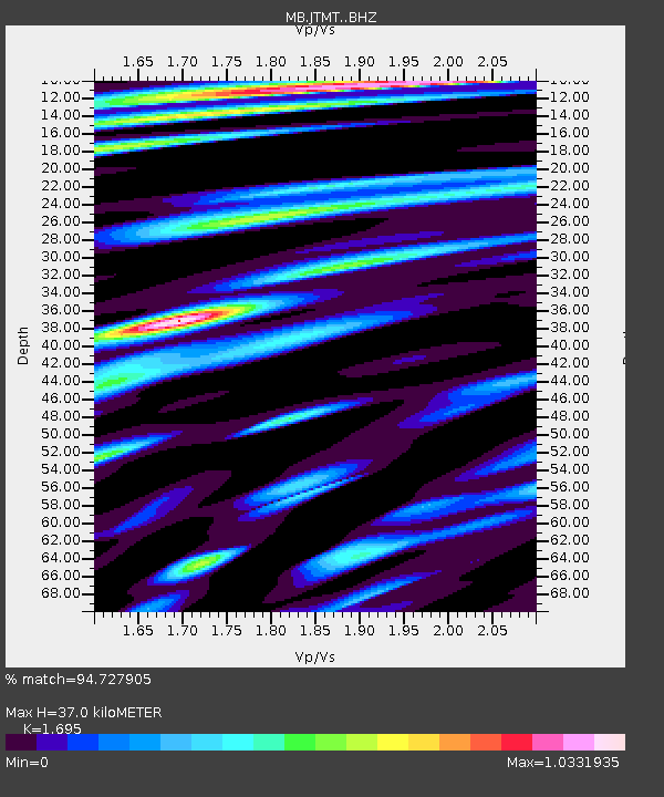
| Estimated Moho Depth: |
37.0 km |
| Estimated Crust Vp/Vs: |
1.70 |
| Assumed Crust Vp: |
6.622 km/s |
| Estimated Crust Vs: |
3.907 km/s |
| Estimated Crust Poisson's Ratio: |
0.23 |
|
| Radial Match: |
94.727905 % |
| Radial Bump: |
400 |
| Transverse Match: |
88.435616 % |
| Transverse Bump: |
400 |
| SOD ConfigId: |
7422571 |
| Insert Time: |
2019-04-21 20:39:31.259 +0000 |
| GWidth: |
2.5 |
| Max Bumps: |
400 |
| Tol: |
0.001 |
|

Signal To Noise
| Channel | StoN | STA | LTA |
| MB:JTMT: :BHZ:20160130T03:33:33.009996Z | 22.841236 | 1.8404948E-5 | 8.0577723E-7 |
| MB:JTMT: :BHN:20160130T03:33:33.009996Z | 23.857552 | 8.22431E-6 | 3.4472563E-7 |
| MB:JTMT: :BHE:20160130T03:33:33.009996Z | 10.1536665 | 6.6123275E-6 | 6.512256E-7 |
| Arrivals |
| Ps | 4.1 SECOND |
| PpPs | 14 SECOND |
| PsPs/PpSs | 18 SECOND |


