You are here: Home > Network List > N4 - Central and EAstern US Network Stations List
> Station 656A Willston, FL, USA > Earthquake Result Viewer
656A Willston, FL, USA - Earthquake Result Viewer
| Earthquake location: |
Kamchatka Peninsula, Russia |
| Earthquake latitude/longitude: |
54.0/158.5 |
| Earthquake time(UTC): |
2016/01/30 (030) 03:25:10 GMT |
| Earthquake Depth: |
161 km |
| Earthquake Magnitude: |
7.2 MWW, 7.0 MI, 7.2 MWB |
| Earthquake Catalog/Contributor: |
NEIC PDE/NEIC COMCAT |
|
| Network: |
N4 Central and EAstern US Network |
| Station: |
656A Willston, FL, USA |
| Lat/Lon: |
29.37 N/82.53 W |
| Elevation: |
28 m |
|
| Distance: |
81.7 deg |
| Az: |
50.519 deg |
| Baz: |
328.538 deg |
| Ray Param: |
0.047019284 |
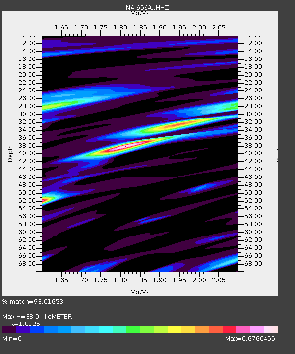
| Estimated Moho Depth: |
38.0 km |
| Estimated Crust Vp/Vs: |
1.81 |
| Assumed Crust Vp: |
5.989 km/s |
| Estimated Crust Vs: |
3.304 km/s |
| Estimated Crust Poisson's Ratio: |
0.28 |
|
| Radial Match: |
93.01653 % |
| Radial Bump: |
314 |
| Transverse Match: |
85.17269 % |
| Transverse Bump: |
400 |
| SOD ConfigId: |
7422571 |
| Insert Time: |
2019-04-21 20:39:57.377 +0000 |
| GWidth: |
2.5 |
| Max Bumps: |
400 |
| Tol: |
0.001 |
|

Signal To Noise
| Channel | StoN | STA | LTA |
| N4:656A: :HHZ:20160130T03:36:39.779985Z | 20.828678 | 1.567894E-5 | 7.527573E-7 |
| N4:656A: :HHN:20160130T03:36:39.779985Z | 7.1346803 | 4.66113E-6 | 6.53306E-7 |
| N4:656A: :HHE:20160130T03:36:39.779985Z | 5.1512995 | 2.7792546E-6 | 5.3952493E-7 |
| Arrivals |
| Ps | 5.3 SECOND |
| PpPs | 17 SECOND |
| PsPs/PpSs | 23 SECOND |


