You are here: Home > Network List > N4 - Central and EAstern US Network Stations List
> Station E28B Huff Hills, Mandan, ND, USA > Earthquake Result Viewer
E28B Huff Hills, Mandan, ND, USA - Earthquake Result Viewer
| Earthquake location: |
Kamchatka Peninsula, Russia |
| Earthquake latitude/longitude: |
54.0/158.5 |
| Earthquake time(UTC): |
2016/01/30 (030) 03:25:10 GMT |
| Earthquake Depth: |
161 km |
| Earthquake Magnitude: |
7.2 MWW, 7.0 MI, 7.2 MWB |
| Earthquake Catalog/Contributor: |
NEIC PDE/NEIC COMCAT |
|
| Network: |
N4 Central and EAstern US Network |
| Station: |
E28B Huff Hills, Mandan, ND, USA |
| Lat/Lon: |
46.57 N/100.69 W |
| Elevation: |
704 m |
|
| Distance: |
59.5 deg |
| Az: |
51.881 deg |
| Baz: |
317.687 deg |
| Ray Param: |
0.061668955 |
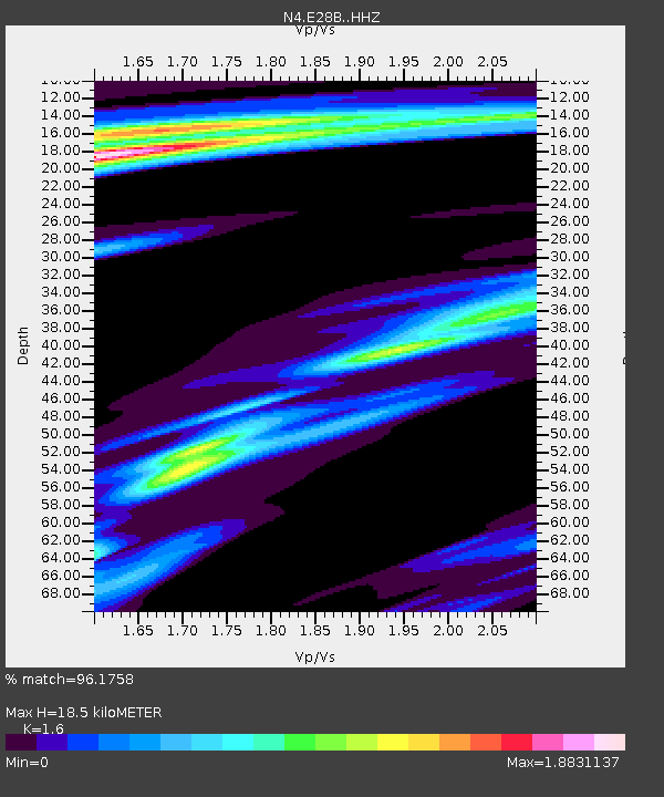
| Estimated Moho Depth: |
18.5 km |
| Estimated Crust Vp/Vs: |
1.60 |
| Assumed Crust Vp: |
6.438 km/s |
| Estimated Crust Vs: |
4.023 km/s |
| Estimated Crust Poisson's Ratio: |
0.18 |
|
| Radial Match: |
96.1758 % |
| Radial Bump: |
273 |
| Transverse Match: |
80.02054 % |
| Transverse Bump: |
400 |
| SOD ConfigId: |
7422571 |
| Insert Time: |
2019-04-21 20:40:02.313 +0000 |
| GWidth: |
2.5 |
| Max Bumps: |
400 |
| Tol: |
0.001 |
|

Signal To Noise
| Channel | StoN | STA | LTA |
| N4:E28B: :HHZ:20160130T03:34:25.69002Z | 48.21989 | 2.5127172E-5 | 5.2109556E-7 |
| N4:E28B: :HHN:20160130T03:34:25.69002Z | 5.691976 | 8.251166E-6 | 1.4496136E-6 |
| N4:E28B: :HHE:20160130T03:34:25.69002Z | 5.673467 | 6.431779E-6 | 1.1336593E-6 |
| Arrivals |
| Ps | 1.8 SECOND |
| PpPs | 7.1 SECOND |
| PsPs/PpSs | 8.9 SECOND |


