You are here: Home > Network List > N4 - Central and EAstern US Network Stations List
> Station M63A Gales Ferry, CT, USA > Earthquake Result Viewer
M63A Gales Ferry, CT, USA - Earthquake Result Viewer
| Earthquake location: |
Kamchatka Peninsula, Russia |
| Earthquake latitude/longitude: |
54.0/158.5 |
| Earthquake time(UTC): |
2016/01/30 (030) 03:25:10 GMT |
| Earthquake Depth: |
161 km |
| Earthquake Magnitude: |
7.2 MWW, 7.0 MI, 7.2 MWB |
| Earthquake Catalog/Contributor: |
NEIC PDE/NEIC COMCAT |
|
| Network: |
N4 Central and EAstern US Network |
| Station: |
M63A Gales Ferry, CT, USA |
| Lat/Lon: |
41.40 N/72.05 W |
| Elevation: |
44 m |
|
| Distance: |
75.5 deg |
| Az: |
36.864 deg |
| Baz: |
331.919 deg |
| Ray Param: |
0.051189516 |
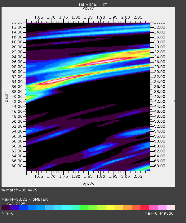
| Estimated Moho Depth: |
33.25 km |
| Estimated Crust Vp/Vs: |
1.72 |
| Assumed Crust Vp: |
6.472 km/s |
| Estimated Crust Vs: |
3.757 km/s |
| Estimated Crust Poisson's Ratio: |
0.25 |
|
| Radial Match: |
89.4479 % |
| Radial Bump: |
330 |
| Transverse Match: |
75.595856 % |
| Transverse Bump: |
400 |
| SOD ConfigId: |
7422571 |
| Insert Time: |
2019-04-21 20:40:42.634 +0000 |
| GWidth: |
2.5 |
| Max Bumps: |
400 |
| Tol: |
0.001 |
|

Signal To Noise
| Channel | StoN | STA | LTA |
| N4:M63A: :HHZ:20160130T03:36:06.250017Z | 12.764033 | 1.6206477E-5 | 1.2696988E-6 |
| N4:M63A: :HHN:20160130T03:36:06.250017Z | 5.8619742 | 5.031372E-6 | 8.583068E-7 |
| N4:M63A: :HHE:20160130T03:36:06.250017Z | 4.864948 | 4.2544475E-6 | 8.7451036E-7 |
| Arrivals |
| Ps | 3.8 SECOND |
| PpPs | 14 SECOND |
| PsPs/PpSs | 17 SECOND |


