You are here: Home > Network List > NM - Cooperative New Madrid Seismic Network Stations List
> Station MPH Memphis, TN > Earthquake Result Viewer
MPH Memphis, TN - Earthquake Result Viewer
| Earthquake location: |
Kamchatka Peninsula, Russia |
| Earthquake latitude/longitude: |
54.0/158.5 |
| Earthquake time(UTC): |
2016/01/30 (030) 03:25:10 GMT |
| Earthquake Depth: |
161 km |
| Earthquake Magnitude: |
7.2 MWW, 7.0 MI, 7.2 MWB |
| Earthquake Catalog/Contributor: |
NEIC PDE/NEIC COMCAT |
|
| Network: |
NM Cooperative New Madrid Seismic Network |
| Station: |
MPH Memphis, TN |
| Lat/Lon: |
35.12 N/89.93 W |
| Elevation: |
93 m |
|
| Distance: |
73.5 deg |
| Az: |
52.677 deg |
| Baz: |
325.066 deg |
| Ray Param: |
0.05256193 |
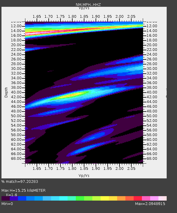
| Estimated Moho Depth: |
15.25 km |
| Estimated Crust Vp/Vs: |
1.60 |
| Assumed Crust Vp: |
6.38 km/s |
| Estimated Crust Vs: |
3.988 km/s |
| Estimated Crust Poisson's Ratio: |
0.18 |
|
| Radial Match: |
97.20283 % |
| Radial Bump: |
277 |
| Transverse Match: |
95.46424 % |
| Transverse Bump: |
321 |
| SOD ConfigId: |
7422571 |
| Insert Time: |
2019-04-21 20:41:53.221 +0000 |
| GWidth: |
2.5 |
| Max Bumps: |
400 |
| Tol: |
0.001 |
|

Signal To Noise
| Channel | StoN | STA | LTA |
| NM:MPH: :HHZ:20160130T03:35:54.347979Z | 61.911102 | 2.993745E-5 | 4.835554E-7 |
| NM:MPH: :HHN:20160130T03:35:54.347979Z | 3.0538766 | 9.389538E-6 | 3.074629E-6 |
| NM:MPH: :HHE:20160130T03:35:54.347979Z | 4.839658 | 8.238555E-6 | 1.7023012E-6 |
| Arrivals |
| Ps | 1.5 SECOND |
| PpPs | 6.0 SECOND |
| PsPs/PpSs | 7.5 SECOND |


