You are here: Home > Network List > NN - Western Great Basin/Eastern Sierra Nevada Stations List
> Station LCH Last Chance Range, CA. (GPS 01/04/2001) w84 > Earthquake Result Viewer
LCH Last Chance Range, CA. (GPS 01/04/2001) w84 - Earthquake Result Viewer
| Earthquake location: |
Kamchatka Peninsula, Russia |
| Earthquake latitude/longitude: |
54.0/158.5 |
| Earthquake time(UTC): |
2016/01/30 (030) 03:25:10 GMT |
| Earthquake Depth: |
161 km |
| Earthquake Magnitude: |
7.2 MWW, 7.0 MI, 7.2 MWB |
| Earthquake Catalog/Contributor: |
NEIC PDE/NEIC COMCAT |
|
| Network: |
NN Western Great Basin/Eastern Sierra Nevada |
| Station: |
LCH Last Chance Range, CA. (GPS 01/04/2001) w84 |
| Lat/Lon: |
37.23 N/117.65 W |
| Elevation: |
1414 m |
|
| Distance: |
57.5 deg |
| Az: |
70.143 deg |
| Baz: |
315.926 deg |
| Ray Param: |
0.06292024 |
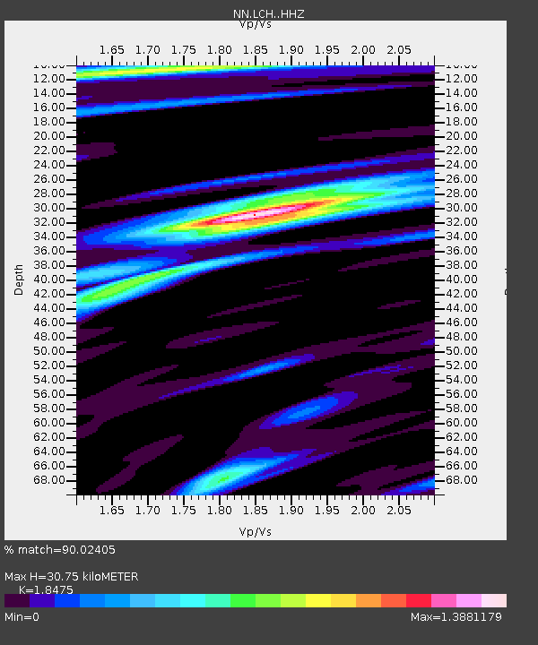
| Estimated Moho Depth: |
30.75 km |
| Estimated Crust Vp/Vs: |
1.85 |
| Assumed Crust Vp: |
6.279 km/s |
| Estimated Crust Vs: |
3.398 km/s |
| Estimated Crust Poisson's Ratio: |
0.29 |
|
| Radial Match: |
90.02405 % |
| Radial Bump: |
400 |
| Transverse Match: |
82.32218 % |
| Transverse Bump: |
400 |
| SOD ConfigId: |
7422571 |
| Insert Time: |
2019-04-21 20:42:05.719 +0000 |
| GWidth: |
2.5 |
| Max Bumps: |
400 |
| Tol: |
0.001 |
|

Signal To Noise
| Channel | StoN | STA | LTA |
| NN:LCH: :HHZ:20160130T03:34:12.357988Z | 14.836784 | 9.688369E-6 | 6.5299656E-7 |
| NN:LCH: :HHN:20160130T03:34:12.357988Z | 7.266318 | 2.7606106E-6 | 3.799188E-7 |
| NN:LCH: :HHE:20160130T03:34:12.357988Z | 6.9832907 | 2.8349993E-6 | 4.05969E-7 |
| Arrivals |
| Ps | 4.3 SECOND |
| PpPs | 13 SECOND |
| PsPs/PpSs | 18 SECOND |


